 Filter: Categories of Wisconsin Historical Images
Filter: Subject of Dams
Filter: Year of 1900-1999
Filter: Year of 1970-1979
Filter: Categories of Wisconsin Historical Images
Filter: Subject of Dams
Filter: Year of 1900-1999
Filter: Year of 1970-1979

| Date: | 1976 |
|---|---|
| Description: | Panel title. Shows railroads, roads, highways, boundaries, dams, public hunting and fishing grounds, cemeteries, forest ranger stations, plant life, and s... |

| Date: | 1975 |
|---|---|
| Description: | This map shows nature trails, public attractions, public hunting and fishing grounds, dams, waysides, lakes, highways, and roads. The upper right corner in... |
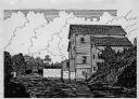
| Date: | 05 06 1973 |
|---|---|
| Description: | Black ink line drawing of a fisherman on the bank of Big Spring Creek near a power house and dam. Puffy clouds fill the sky in the background and thick veg... |
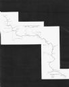
| Date: | 1971 |
|---|---|
| Description: | This map shows major tributaries, and also covers parts of Marathon and Portage Counties. |
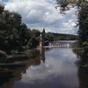
| Date: | 07 1971 |
|---|---|
| Description: | View looking upriver towards the Jaeger Rye Mill, also known as the Danville Mill, on the left in front of a small dam. Trees are along the banks of the Cr... |
If you didn't find the material you searched for, our Library Reference Staff can help.
Call our reference desk at 608-264-6535 or email us at: