 Filter: Categories of Wisconsin Historical Images
Filter: Subject of Dams
Filter: Year of 1800-1899
Filter: Year of 1880-1889
Filter: Categories of Wisconsin Historical Images
Filter: Subject of Dams
Filter: Year of 1800-1899
Filter: Year of 1880-1889
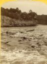
| Date: | 1886 |
|---|---|
| Description: | Stereograph of Jim Short steering a raft riding the rough waters of the river. |
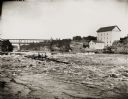
| Date: | 08 24 1886 |
|---|---|
| Description: | View across water of several men steering a lumber raft over the dam at Munger's Mill. A second raft is in the background, in front of railroad bridge. |

| Date: | 12 21 1882 |
|---|---|
| Description: | Bird's-eye map of Kaukauna, from the Appleton Post Annual Review. |

| Date: | 1880 |
|---|---|
| Description: | A hand-colored map of the Chippewa, Price, Taylor and the northern part of Clark counties, which shows the locations of farmhouses, schoolhouses, churches,... |

| Date: | 1880 |
|---|---|
| Description: | This 1880 map of Clark County, Wisconsin, shows the township and range grid, towns, sections, cities and villages, railroads, roads, rivers and lakes, dams... |

| Date: | 11 30 1882 |
|---|---|
| Description: | This 1882 manuscript map shows the improvements to a 12-mile stretch of the Wisconsin River below Portage, in Columbia County, Wisconsin. Recent improvemen... |

| Date: | 1889 |
|---|---|
| Description: | Shows city limits, railroads, mills, schools, cemeteries, dams, parks, lumber yards, log canals, log reservoir, Chippewa River, Eau Claire River, and Half ... |
If you didn't find the material you searched for, our Library Reference Staff can help.
Call our reference desk at 608-264-6535 or email us at: