 Filter: Categories of Wisconsin Historical Images
Filter: Subject of Dams
Filter: Year of 1800-1899
Filter: Year of 1870-1879
Filter: Categories of Wisconsin Historical Images
Filter: Subject of Dams
Filter: Year of 1800-1899
Filter: Year of 1870-1879

| Date: | 1872 |
|---|---|
| Description: | Birds-eye drawing of Eau Claire depicts street names and street locations, houses, trees, bridges, piers, canals, railroads, and the Chippewa and Eau Clair... |

| Date: | 1874 |
|---|---|
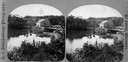
| Description: | Elevated view from hill of Clinton, now Rockdale. Three men are in the middle distance, looking east across Koshonong Creek towards a mill dam, bridge and ... |
| Date: | 1875 |
|---|---|
| Description: | View of a bridge, dam and mill. Moscow was platted in 1850 by an Englishman, Chauncy Smith, who dammed the Bluemound branch of the Pecatonica River to run ... |
| Date: | 1870 |
|---|---|
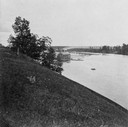
| Description: | Overlook of the river, and a building near the dam from a steep hillside. |
| Date: | 1870 |
|---|---|
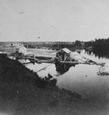
| Description: | View from a hillside of either houses or factory buildings on the Fox River near a dam. |
| Date: | 1876 |
|---|---|
| Description: | Elevated view of Fort Howard taken from Elmore and Kelly's Elevator with the dam and river. A tugboat is in the river above the dam. Caption reads: "View o... |

| Date: | 1876 |
|---|---|
| Description: | Elevated view showing Elmore and Kelly's Elevator with a boat, train, and the buildings at Fort Howard. Fort Howard was incorporated into Green Bay. Captio... |

| Date: | 1873 |
|---|---|
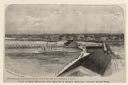
| Description: | Engraved image of a lock and dam at Sault St. Marie. Two men are operating the sluice as ships are waiting on the opposite side of the lock. Another man is... |
| Date: | 1873 |
|---|---|
| Description: | This 1873 map shows Clark County, Wisconsin, as well as the portion of Taylor County that was then part of Clark. The township and range grid, sections, ra... |

| Date: | 06 1875 |
|---|---|
| Description: | These manuscript drawings show the profile of the Neenah Dam, between Lake Winnebago and Little Lake Butte des Morts on the Fox River in Winnebago County, ... |

| Date: | 1875 |
|---|---|
| Description: | One of a set of maps from G.K. Warren's 1876 Report on the transportation route along the Wisconsin and Fox rivers in the State of Wisconsin between the Mi... |

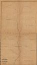
| Date: | 1873 |
|---|---|
| Description: | This 1873 map of Chippewa County, Wisconsin, which at the time also encompassed all or part of Price, Rusk, Sawyer, and Taylor counties, shows the township... |

| Date: | 1877 |
|---|---|
| Description: | Relief shown by hachures. Shows land ownership by name, wards, railroads, mills, dams, city limits, Chippewa River, and Half Moon Lake. Includes index of m... |

| Date: | 1877 |
|---|---|
| Description: | Relief shown by hachures. Shows land ownership by name, wards, railroads, mills, dams, city limits, Chippewa River, and Half Moon Lake. Includes index of m... |

| Date: | 1875 |
|---|---|
| Description: | This blue line print map shows completed and proposed dams, completed and proposed shore protections, and completed spurs. The map covers the river between... |
If you didn't find the material you searched for, our Library Reference Staff can help.
Call our reference desk at 608-264-6535 or email us at: