 Filter: Categories of Wisconsin Historical Images
Filter: Subject of Dams
Filter: Year of 1800-1899
Filter: Year of 1860-1869
Filter: Categories of Wisconsin Historical Images
Filter: Subject of Dams
Filter: Year of 1800-1899
Filter: Year of 1860-1869

| Date: | 1864 |
|---|---|
| Description: | This map shows pictorially a section of bracketdam, section of tree dam, and crib of stone. This map was prepared by order of General Joseph Bailey and is ... |

| Date: | 1866 |
|---|---|
| Description: | Full-length portrait of Morgan L. Martin standing in a landscape, with a dog sitting at his feet. |
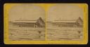
| Date: | 1867 |
|---|---|
| Description: | Mill dam and sash factory. "The Northwester Gateway. Excursion to Lake Superior, June 1867. Photographed and Published by J. Carbutt, 131 Lake St., Chicago... |

| Date: | 1867 |
|---|---|
| Description: | Drawn map showing planned development of Cornell, including a couple of schools, Oakwood cemetery, the public square, and several bridges and dams. |
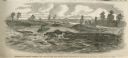
| Date: | 06 18 1864 |
|---|---|
| Description: | Engraved view of gunboats passing the dam in the Red River near Alexandria. |

| Date: | 1866 |
|---|---|
| Description: | This manuscript map by Increase Lapham shows the Dells of the Wisconsin River, from Stand Rock and Witches Gulch at the north to a point approximately one ... |

| Date: | 1861 |
|---|---|
| Description: | This map shows townships and sections, landownership, roads, railroads, rural residences, schools, churches, and topography. Also included are inset maps o... |
If you didn't find the material you searched for, our Library Reference Staff can help.
Call our reference desk at 608-264-6535 or email us at: