 Filter: Categories of Wisconsin Historical Images
Filter: Subject of Dams
Filter: Year of 1800-1899
Filter: Subject of dams
Filter: Categories of Wisconsin Historical Images
Filter: Subject of Dams
Filter: Year of 1800-1899
Filter: Subject of dams

| Date: | 1864 |
|---|---|
| Description: | This map shows pictorially a section of bracketdam, section of tree dam, and crib of stone. This map was prepared by order of General Joseph Bailey and is ... |

| Date: | 1866 |
|---|---|
| Description: | Full-length portrait of Morgan L. Martin standing in a landscape, with a dog sitting at his feet. |
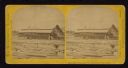
| Date: | 1867 |
|---|---|
| Description: | Mill dam and sash factory. "The Northwester Gateway. Excursion to Lake Superior, June 1867. Photographed and Published by J. Carbutt, 131 Lake St., Chicago... |
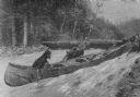
| Date: | 03 1892 |
|---|---|
| Description: | Three men are dragging their canoe upriver through a strong current. In the background other men are standing on the far river bank near canoes pulled up o... |
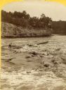
| Date: | 1886 |
|---|---|
| Description: | Stereograph of Jim Short steering a raft riding the rough waters of the river. |
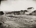
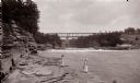
| Date: | 08 24 1886 |
|---|---|
| Description: | View across water of several men steering a lumber raft over the dam at Munger's Mill. A second raft is in the background, in front of railroad bridge. |
| Date: | 1890 |
|---|---|
| Description: | Below Kilbourn log dam, 1890s. Two girls are standing on the edge of the river. There is a bridge in the background. |

| Date: | 1872 |
|---|---|
| Description: | Birds-eye drawing of Eau Claire depicts street names and street locations, houses, trees, bridges, piers, canals, railroads, and the Chippewa and Eau Clair... |

| Date: | 1893 |
|---|---|
| Description: | Bird's-eye map of Jefferson, looking north. Crayfish River at left and center, Rock River from upper center to bottom center, joins at left of center; thir... |

| Date: | 12 21 1882 |
|---|---|
| Description: | Bird's-eye map of Kaukauna, from the Appleton Post Annual Review. |

| Date: | 1874 |
|---|---|
| Description: | Elevated view from hill of Clinton, now Rockdale. Three men are in the middle distance, looking east across Koshonong Creek towards a mill dam, bridge and ... |
| Date: | 1875 |
|---|---|
| Description: | View of a bridge, dam and mill. Moscow was platted in 1850 by an Englishman, Chauncy Smith, who dammed the Bluemound branch of the Pecatonica River to run ... |
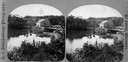
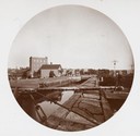
| Date: | 1870 |
|---|---|
| Description: | Overlook of the river, and a building near the dam from a steep hillside. |
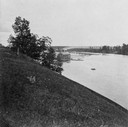
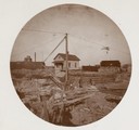
| Date: | 1870 |
|---|---|
| Description: | View from a hillside of either houses or factory buildings on the Fox River near a dam. |

| Date: | 1867 |
|---|---|
| Description: | Drawn map showing planned development of Cornell, including a couple of schools, Oakwood cemetery, the public square, and several bridges and dams. |
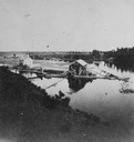
| Date: | 1897 |
|---|---|
| Description: | De Pere lock on the Fox River with a construction crew at work. This is the only wooden lock on the Fox River. |
| Date: | 1897 |
|---|---|
| Description: | Locks near De Pere, the only wooden pier on the Fox River. |
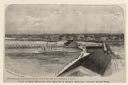
| Date: | 1876 |
|---|---|
| Description: | Elevated view of Fort Howard taken from Elmore and Kelly's Elevator with the dam and river. A tugboat is in the river above the dam. Caption reads: "View o... |

| Date: | 1876 |
|---|---|
| Description: | Elevated view showing Elmore and Kelly's Elevator with a boat, train, and the buildings at Fort Howard. Fort Howard was incorporated into Green Bay. Captio... |
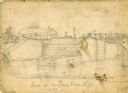
| Date: | 1856 |
|---|---|
| Description: | An original illustration of the lock at Rexford Flats. |
If you didn't find the material you searched for, our Library Reference Staff can help.
Call our reference desk at 608-264-6535 or email us at: