 Filter: Categories of Wisconsin Historical Images
Filter: Subject of Dams
Filter: Subject of trails
Filter: Categories of Wisconsin Historical Images
Filter: Subject of Dams
Filter: Subject of trails

| Date: | 1873 |
|---|---|
| Description: | This 1873 map of Chippewa County, Wisconsin, which at the time also encompassed all or part of Price, Rusk, Sawyer, and Taylor counties, shows the township... |

| Date: | 1960 |
|---|---|
| Description: | This manuscript map of Taylor County, Wisconsin, shows the township and range grid, lakes and streams, "Chippewa trails, Indian trails" Indian villages and... |

| Date: | 1975 |
|---|---|
| Description: | This map shows nature trails, public attractions, public hunting and fishing grounds, dams, waysides, lakes, highways, and roads. The upper right corner in... |
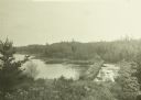
| Date: | 1911 |
|---|---|
| Description: | An elevated view of the bridge and dam on the Old Dawson Trail at the end of Sturgeon Lake. The dam was built in 1873 by Simon Dawson. |
If you didn't find the material you searched for, our Library Reference Staff can help.
Call our reference desk at 608-264-6535 or email us at: