 Filter: Categories of Wisconsin Historical Images
Filter: Subject of Dams
Filter: Subject of streets
Filter: Categories of Wisconsin Historical Images
Filter: Subject of Dams
Filter: Subject of streets

| Date: | 1893 |
|---|---|
| Description: | Bird's-eye map of Jefferson, looking north. Crayfish River at left and center, Rock River from upper center to bottom center, joins at left of center; thir... |

| Date: | 12 21 1882 |
|---|---|
| Description: | Bird's-eye map of Kaukauna, from the Appleton Post Annual Review. |
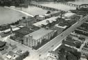
| Date: | 1924 |
|---|---|
| Description: | Aerial view of the International Harvester Rock Falls Works (factory). |
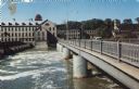
| Date: | |
|---|---|
| Description: | Color postcard view of the Fox River Bridge. Two cars are driving across the bridge towards the Fox River Paper Corp. |

| Date: | 1877 |
|---|---|
| Description: | Relief shown by hachures. Shows land ownership by name, wards, railroads, mills, dams, city limits, Chippewa River, and Half Moon Lake. Includes index of m... |

| Date: | 1877 |
|---|---|
| Description: | Relief shown by hachures. Shows land ownership by name, wards, railroads, mills, dams, city limits, Chippewa River, and Half Moon Lake. Includes index of m... |

| Date: | 1889 |
|---|---|
| Description: | Shows city limits, railroads, mills, schools, cemeteries, dams, parks, lumber yards, log canals, log reservoir, Chippewa River, Eau Claire River, and Half ... |
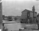
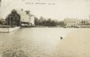
| Date: | 1921 |
|---|---|
| Description: | View from shoreline over the Baraboo River towards a dam, with a mill on the opposite shoreline. A bridge and a business district are in the background. |
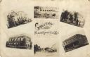
| Date: | |
|---|---|
| Description: | Photographic collage of six views of Black River Falls, featuring the Grade School, High School, Bank, Main Street, a commercial business block and the da... |

| Date: | 1828 |
|---|---|
| Description: | Map of the Louisville and Portland Canal on the Ohio River. The map shows Louisville, Shippingsport, Clarksville, Jeffersonville, Gravel Island, Corn Islan... |

| Date: | 1890 |
|---|---|
| Description: | This map is a plat map and shows government buildings, churches, Klein’s Park, and the government dam in Kaukauna. The map includes text about Kaukauna wit... |

| Date: | 1846 |
|---|---|
| Description: | This plat map, which features the very early spelling of Wisconsin as "Wiskonsin", was created sometime between 1846 and 1854 and shows a canal and dam on ... |

| Date: | 1939 |
|---|---|
| Description: | This map originally dated March 18, 1920 and revised for this edition. The map shows the original meander line of 'Shebowegan Lake' established by 1850 sur... |
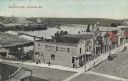
| Date: | |
|---|---|
| Description: | Elevated view of a row of businesses along the Fox River near the dam. There are horse-drawn vehicles in the street. Advertisements are on the side of the ... |

| Date: | 1940 |
|---|---|
| Description: | Elevated view of a dam, bridge over the river and part of the town with many trees. Caption reads: "The Dam, on the Apple River - Somerset, Wis." |
| Date: | 1910 |
|---|---|
| Description: | Text on front reads: "Scene at Weyauwega, Wis." View across water towards the Weyauwega Mills and grain elevator on the left, with a horse-drawn wagon on t... |
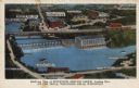
| Date: | 1935 |
|---|---|
| Description: | Text on front reads: "Bird's-eye View of Riverview Service Group, Looking East, At The Dells, Wisconsin Dells, Wisconsin." On reverse: "All the world knows... |
If you didn't find the material you searched for, our Library Reference Staff can help.
Call our reference desk at 608-264-6535 or email us at: