 Filter: Categories of Wisconsin Historical Images
Filter: Subject of Dams
Filter: Subject of railroads
Filter: Categories of Wisconsin Historical Images
Filter: Subject of Dams
Filter: Subject of railroads

| Date: | 1872 |
|---|---|
| Description: | Birds-eye drawing of Eau Claire depicts street names and street locations, houses, trees, bridges, piers, canals, railroads, and the Chippewa and Eau Clair... |

| Date: | 1893 |
|---|---|
| Description: | Bird's-eye map of Jefferson, looking north. Crayfish River at left and center, Rock River from upper center to bottom center, joins at left of center; thir... |

| Date: | 12 21 1882 |
|---|---|
| Description: | Bird's-eye map of Kaukauna, from the Appleton Post Annual Review. |

| Date: | 1930 |
|---|---|
| Description: | Aerial view of the city and the river. |

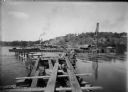
| Date: | 1876 |
|---|---|
| Description: | Elevated view showing Elmore and Kelly's Elevator with a boat, train, and the buildings at Fort Howard. Fort Howard was incorporated into Green Bay. Captio... |

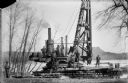
| Date: | 1911 |
|---|---|
| Description: | Workers erecting a steam driven pile driver while others survey for the railroad extension from the village of Prairie du Sac to the dam site on the Wiscon... |
| Date: | 04 1911 |
|---|---|
| Description: | Workmen pose on a steam-powered pile driver at work at the north end of the slough on the Wisconsin River. The railroad was extended from the village to th... |
| Date: | 08 15 1911 |
|---|---|
| Description: | Dam site on the Wisconsin river, looking southwest along the unfinished narrow gauge railroad trestle. The coffer dam and two pile drivers are also visible... |
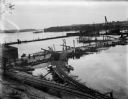
| Date: | 10 07 1911 |
|---|---|
| Description: | Elevated view of the rising waters of the Wisconsin River at the construction site. This view shows the coffer dam, pile drivers, and narrow gauge railroad... |
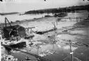
| Date: | 10 11 1911 |
|---|---|
| Description: | Elevated view of high water on the Wisconsin River which has inundated the coffer dam at the construction site. The narrow gauge railroad (curved line in f... |
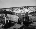
| Date: | |
|---|---|
| Description: | Three women playfully pose among logs near a railroad bridge that passes over a dam. On the bridge, a standing man is visible. |

| Date: | |
|---|---|
| Description: | Elevated view of the camp and valley of the site of the Elephant Butte Dam near Truth or Consequences. There are buildings, roads, railroad tracks, and tra... |
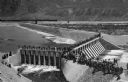
| Date: | 1903 |
|---|---|
| Description: | Elevated view of Derby Diversion Dam with a crowd gathered on the rim of the dam and individuals standing along its top. A train cuts across the horizon in... |

| Date: | |
|---|---|
| Description: | Elevated view of factories and railway line along the Fox River. Caption reads: "View of Water Power from Wests Park, Appleton, Wis." |

| Date: | 1880 |
|---|---|
| Description: | A hand-colored map of the Chippewa, Price, Taylor and the northern part of Clark counties, which shows the locations of farmhouses, schoolhouses, churches,... |

| Date: | 1897 |
|---|---|
| Description: | This 1897 map of Sawyer County, Wisconsin, shows the township and range system, sections, roads, farm houses, camps, school houses, dams, bridges, Indian r... |

| Date: | |
|---|---|
| Description: | This map shows the township and range system, sections, dam locations, railroads, roads, selected buildings, and lakes and streams in Sawyer County, Wiscon... |

| Date: | 1909 |
|---|---|
| Description: | This 1909 map of Taylor County, Wisconsin, shows the township and range grid, towns, sections, cities and villages, settlers houses, schools, churches, saw... |

| Date: | |
|---|---|
| Description: | This map of Taylor County, Wisconsin, shows soil types, the township and range grid, sections, settlers houses, schools, churches, saw mills, tanneries, ro... |

| Date: | 1880 |
|---|---|
| Description: | This 1880 map of Clark County, Wisconsin, shows the township and range grid, towns, sections, cities and villages, railroads, roads, rivers and lakes, dams... |
If you didn't find the material you searched for, our Library Reference Staff can help.
Call our reference desk at 608-264-6535 or email us at: