 Filter: Categories of Wisconsin Historical Images
Filter: Subject of Dams
Filter: Subject of church buildings
Filter: Categories of Wisconsin Historical Images
Filter: Subject of Dams
Filter: Subject of church buildings

| Date: | 1872 |
|---|---|
| Description: | Birds-eye drawing of Eau Claire depicts street names and street locations, houses, trees, bridges, piers, canals, railroads, and the Chippewa and Eau Clair... |

| Date: | 1893 |
|---|---|
| Description: | Bird's-eye map of Jefferson, looking north. Crayfish River at left and center, Rock River from upper center to bottom center, joins at left of center; thir... |

| Date: | 12 21 1882 |
|---|---|
| Description: | Bird's-eye map of Kaukauna, from the Appleton Post Annual Review. |
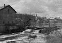
| Date: | 1948 |
|---|---|
| Description: | Elevated view from shoreline towards the opposite shoreline towards the Buettner mill on the left, and the river with a dam, on the right. In the backgroun... |
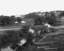
| Date: | 1900 |
|---|---|
| Description: | Elevated view from the south. The Fox River is in the foreground with the dam just visible in the lower right. The lock is seen in the center; the Montello... |
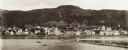
| Date: | 1897 |
|---|---|
| Description: | View of Alma from the Mississippi River, with wing dam on right. |
| Date: | |
|---|---|
| Description: | Elevated view of a stream with a dam and a bridge. There is a small fenced garden along the water. In the distance is a hillside with houses. |

| Date: | 1880 |
|---|---|
| Description: | A hand-colored map of the Chippewa, Price, Taylor and the northern part of Clark counties, which shows the locations of farmhouses, schoolhouses, churches,... |

| Date: | 11 28 1992 |
|---|---|
| Description: | "This dam was constructed in 1917. Costs were funded by voluntary contributions totaling $206. Those who did not contribute were expected to donate their... |

| Date: | 1897 |
|---|---|
| Description: | This 1897 map of Sawyer County, Wisconsin, shows the township and range system, sections, roads, farm houses, camps, school houses, dams, bridges, Indian r... |

| Date: | 1898 |
|---|---|
| Description: | This 1898 map of Sawyer County, Wisconsin, shows the township and range system, sections, roads, farm houses, camps, school houses, dams, bridges, Indian r... |

| Date: | 1873 |
|---|---|
| Description: | This 1873 map of Chippewa County, Wisconsin, which at the time also encompassed all or part of Price, Rusk, Sawyer, and Taylor counties, shows the township... |

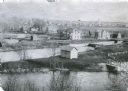
| Date: | 1908 |
|---|---|
| Description: | Elevated photographic view of the town of Blanchardville with the commercial district on the left, and residential neighborhoods on the right. The river is... |

| Date: | 12 1992 |
|---|---|
| Description: | Built in 1916, the Theresa Village Dam has played a large part in the appearance of the Rock River. Dam is pictured in winter. |

| Date: | 1890 |
|---|---|
| Description: | This map is a plat map and shows government buildings, churches, Klein’s Park, and the government dam in Kaukauna. The map includes text about Kaukauna wit... |
| Date: | 1909 |
|---|---|
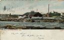
| Description: | Colorized view of Big Mill, a lumber sawmill on the Chippewa river, next to a churning rapids. In the foreground are loose logs, whitewater, river boulders... |
| Date: | 1909 |
|---|---|
| Description: | View of Kekoskee from across the Rock River. Caption reads: "Kekoskee, Wis." |

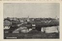
| Date: | 1915 |
|---|---|
| Description: | View of the Upper Dam on the Rock River near Mayville. A church is on the hill on the left. Caption reads: "Upper Dam, Mayville, Wis." |
If you didn't find the material you searched for, our Library Reference Staff can help.
Call our reference desk at 608-264-6535 or email us at:
