Filter: Categories of Wisconsin Historical Images
Filter: Subject of Dams
Filter: Subject of aerial photographs
Filter: Categories of Wisconsin Historical Images
Filter: Subject of Dams
Filter: Subject of aerial photographs

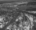
| Date: | 1930 |
|---|---|
| Description: | Aerial view of the city and the river. |

| Date: | 1931 |
|---|---|
| Description: | Aerial view looking north, with a small portion of the West Side (left), nearly all of the North Side and part of the business district of the East Side. A... |
| Date: | 1930 |
|---|---|
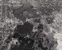
| Description: | Aerial view of the town of Wisconsin Dells, the dam on the Wisconsin River, and the generating plant. The town of Wisconsin Dells was known as Kilbourn Cit... |

| Date: | 1930 |
|---|---|
| Description: | Aerial view of Wisconsin Dells including the Wisconsin River and the dam and generating power plant. |
| Date: | 1940 |
|---|---|
| Description: | Aerial view of the Wisconsin Power and Light Company generating plant and dam. |
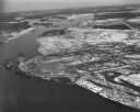
| Date: | 1948 |
|---|---|
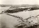
| Description: | The Kimberly-Clark paper mill on the Fox River. |

| Date: | 1965 |
|---|---|
| Description: | Aerial view that encompasses most of the town and part of the Wisconsin River. |
| Date: | 1955 |
|---|---|
| Description: | Aerial view of Castle Rock Dam on the Wisconsin River. |

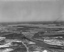
| Date: | 1950 |
|---|---|
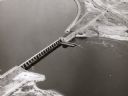
| Description: | Aerial view of the Highway 21 bridge and Petenwell Dam on the Wisconsin River. |
| Date: | 1924 |
|---|---|
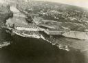
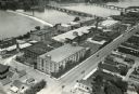
| Description: | Aerial view of the International Harvester Rock Falls Works (factory). |
| Date: | 1924 |
|---|---|
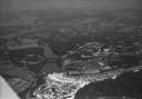
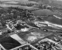
| Description: | Aerial view of the Prairie du Sac hydroelectric plant and the surrounding landscape of the Wisconsin River. |
| Date: | 04 16 1949 |
|---|---|
| Description: | Aerial view of Necedah, Wisconsin, and Petenwell Lake behind Petenwell Dam on the Wisconsin River. |
| Date: | 04 16 1949 |
|---|---|
| Description: | Aerial view of Castle Rock Dam on the Wisconsin River near Mauston, Wisconsin. |
| Date: | 04 16 1949 |
|---|---|
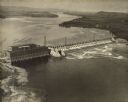
| Description: | Aerial view of Petenwell Dam and dike on Wisconsin River twenty miles north of Necedah, Wisconsin showing the early formation of Lake Petenwell. |
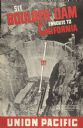
| Date: | 1935 |
|---|---|
| Description: | An original lithograph promoting the Boulder Dam enroute to California via the Union Pacific Railway. The poster features an aerial photograph of the "Worl... |
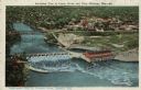
| Date: | 1924 |
|---|---|
| Description: | Illustration based on an aerial photograph of a powerhouse and dam on the Wisconsin River. A railroad bridge is upriver. The city of Kilbourn (now Wisconsi... |
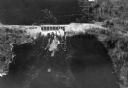
| Date: | 1940 |
|---|---|
| Description: | Aerial view, looking upstream, of water flowing through a dam. On the reverse of the print is written: "Dam built by WPA on site of old logging dam on the ... |

| Date: | 09 14 1938 |
|---|---|
| Description: | Aerial, panoramic view towards the Chickamauga Dam. |
If you didn't find the material you searched for, our Library Reference Staff can help.
Call our reference desk at 608-264-6535 or email us at: