 Filter: Categories of Wisconsin Historical Images
Filter: Subject of Dams
Filter: Creator Name of Wisconsin Valley Improvement Company.
Filter: Categories of Wisconsin Historical Images
Filter: Subject of Dams
Filter: Creator Name of Wisconsin Valley Improvement Company.
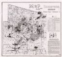
| Date: | 1987 |
|---|---|
| Description: | This map shows reservoirs, drainage areas, and parts of of Lincoln, Langlade, Forest, Oneida, and Vilas counties. Includes 1 inset map of corrections for R... |
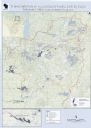
| Date: | 2013 |
|---|---|
| Description: | This map shows hydroelectric dams, natural-lake and man-made reservoirs, the Wisconsin River and its tributaries, and the Wisconsin River Drainage Basin. T... |
If you didn't find the material you searched for, our Library Reference Staff can help.
Call our reference desk at 608-264-6535 or email us at: