 Filter: Categories of Wisconsin Historical Images
Filter: Subject of Dairy products industry
Filter: Subject of land
Filter: Categories of Wisconsin Historical Images
Filter: Subject of Dairy products industry
Filter: Subject of land
| Date: | 1910 |
|---|---|
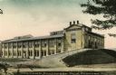
| Description: | View of the Van Camp Condensed Milk Factory. A driveway on the right leads up a small hill to the right side of the factory. Caption reads: "Van Camp Conde... |

| Date: | 1918 |
|---|---|
| Description: | Map illlustrates creameries, condenseries and cheese factories in Wisconsin, January, 1918, and value of products. Five smaller maps in margin show changes... |

| Date: | 1910 |
|---|---|
| Description: | "There never was but one Crop of Land. There never will be another." Shows towns, boundaries, roads, schoolhouses, sawmills, cheese factories, and creameri... |

| Date: | |
|---|---|
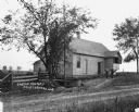
| Description: | View across road of a cheese factory on the side of a hill. Several people are walking down the driveway, and a car is parked nearby. |
| Date: | |
|---|---|
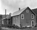
| Description: | A man poses outdoors in front of a cheese factory. Behind him next to the building is a large wooden tub on stilts, perhaps for holding water. |

| Date: | 1922 |
|---|---|
| Description: | Exterior of the Chaseburg Cooperative Creamery. Smoke comes from the back of the building. There is an advertisement for C.R. Watterson, "the painless dent... |

| Date: | 1922 |
|---|---|
| Description: | Exterior of the Chaseburg Cooperative Creamery and an attached secondary building. |
| Date: | 1922 |
|---|---|
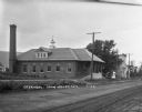
| Description: | Exterior view across road of a creamery. The front of the creamery has a roof supported with columns over the elevated driveway and loading dock for delive... |
| Date: | 1920 |
|---|---|
| Description: | View across dirt road of two men wearing overalls standing outside a rural cheese factory. There is a large, low wooden tub at the driveway entrance, and a... |
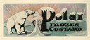
| Date: | 07 02 1935 |
|---|---|
| Description: | Label submitted to the State of Wisconsin for trademark registration. Features a polar bear licking a large ice cream cone. There are floating blocks of ic... |

| Date: | 07 29 1935 |
|---|---|
| Description: | Label submitted to the State of Wisconsin for trademark registration. "Frigid Frozen Custard." Features two men, each driving a dog sled with teams of dogs... |
| Date: | 05 1980 |
|---|---|
| Description: | "On a hillside off McArthur Road, waste water from Widmer Cheese Factory is dumped into a ridge & furrow disposal system." |
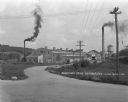
| Date: | 1925 |
|---|---|
| Description: | Exterior of the Nestle Food Condensery plant. |
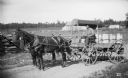
| Date: | 07 09 1895 |
|---|---|
| Description: | Man driving a cream wagon pulled by a team of horses and loaded with dairy products. |

| Date: | 1909 |
|---|---|
| Description: | A map of Langlade County, Wisconsin that shows townships and ranges, towns, cities and villages, wagon roads, churches, schools, sawmills, town halls, chee... |

| Date: | 1915 |
|---|---|
| Description: | This 1915 map of Lincoln County, Wisconsin, shows the township and range grid, towns, cities and villages, lakes and streams, residences, churches, school ... |

| Date: | 1926 |
|---|---|
| Description: | A map of Lincoln County, Wisconsin that shows the township and range grid, towns, cities and villages, lakes and streams, residences, churches, school hous... |

| Date: | |
|---|---|
| Description: | This 1907 map of Outagamie County, Wisconsin, shows the township and range grid, towns, sections, cities and villages, railroads, wagon roads, churches, sc... |

| Date: | 1922 |
|---|---|
| Description: | This map of Outagamie County, Wisconsin, from the first half of the 20th century, shows the township and range grid, towns, sections, cities and villages, ... |

| Date: | |
|---|---|
| Description: | This map from the early 20th century shows the township and range grid, towns, sections, cities and villages, railroads, roads, schools, churches, cemeteri... |
If you didn't find the material you searched for, our Library Reference Staff can help.
Call our reference desk at 608-264-6535 or email us at: