 Filter: Categories of Wisconsin Historical Images
Filter: Subject of Courthouses
Filter: Type of Map or Atlas
Filter: Year of 1900-1999
Filter: Categories of Wisconsin Historical Images
Filter: Subject of Courthouses
Filter: Type of Map or Atlas
Filter: Year of 1900-1999
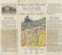
| Date: | 1922 |
|---|---|
| Description: | Wisconsin Geological and Natural History Survey soil map of Wisconsin supplemented by promotional materials about the County's prospects, schools and agric... |

| Date: | 1947 |
|---|---|
| Description: | Shows lot and block numbers, 28 points of interest in the upper left that correspond to numbers on the map, and landownership with acreages. "Erickson Brot... |
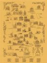
| Date: | 1970 |
|---|---|
| Description: | This pictorial map shows illustrations of historical landmarks and events, some of which include the fairgrounds, churches, the courthouse, Turner Opera Ho... |

| Date: | 06 1959 |
|---|---|
| Description: | This blue line print map shows lot and block numbers and dimensions, fair grounds, schools, court house, parks, and the street numbering system. The Crawfi... |

| Date: | 1990 |
|---|---|
| Description: | This map includes two insets: Plat of New Holstein village and Village of Chilton. The map also includes a table of statistics showing the assessed value o... |
If you didn't find the material you searched for, our Library Reference Staff can help.
Call our reference desk at 608-264-6535 or email us at: