 Filter: Categories of Wisconsin Historical Images
Filter: Subject of Country clubs
Filter: Type of Map or Atlas
Filter: Subject of roads
Filter: Categories of Wisconsin Historical Images
Filter: Subject of Country clubs
Filter: Type of Map or Atlas
Filter: Subject of roads

| Date: | 1927 |
|---|---|
| Description: | Color map, hand-drawn with comic figures engaged in various activities throughout map. Bordered by the river on the left and Lake Michigan on the right, in... |

| Date: | 1930 |
|---|---|
| Description: | This manuscript map, likely drawn in the 1930s, shows Fox Lake, in Dodge County, Wisconsin, and the roads and resorts in the vicinity. |

| Date: | 1940 |
|---|---|
| Description: | Shows Milwaukee and Waukesha counties, and parts of Dodge, Washington, Ozaukee, Jefferson, Walworth, and Racine counties. Includes indexes of "Cities, Town... |
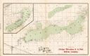
| Date: | 1902 |
|---|---|
| Description: | A map of Lake Geneva and Lake Delavan, also including Lake Como. |
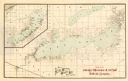
| Date: | 1907 |
|---|---|
| Description: | A map of Lake Geneva and Lake Delavan, including Lake Como. |

| Date: | 1939 |
|---|---|
| Description: | This is a zoning map of Wauwatosa with a key of districts including agricultural, resident, business, commercial, and industrial. The map features labeled ... |

| Date: | 1909 |
|---|---|
| Description: | Bird's-eye view of Lake Geneva from the south extending to Waukesha and Milwaukee in the north. Delavan Lake and Lake Como are identified. Several electric... |
If you didn't find the material you searched for, our Library Reference Staff can help.
Call our reference desk at 608-264-6535 or email us at: