 Filter: Categories of Wisconsin Historical Images
Filter: Subject of Commercial strips
Filter: Subject of water
Filter: Categories of Wisconsin Historical Images
Filter: Subject of Commercial strips
Filter: Subject of water

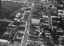
| Date: | 12 07 1952 |
|---|---|
| Description: | Fauerbach Brewery, 651-653 Williamson Street, at the corner of South Blount Street and Williamson Street. The view includes R.J. Olson Glass Co., 625 Willi... |

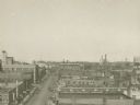
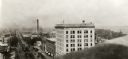
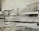
| Date: | 1875 |
|---|---|
| Description: | Elevated view of a shopping district street near a river, with several businesses lining the street, and two carriages. A building across the street has le... |
| Date: | 1924 |
|---|---|
| Description: | Aerial view of Green Bay's commercial district, bridges, and water. |
| Date: | 1920 |
|---|---|
| Description: | Aerial view of Green Bay's commercial waterfront district on the Fox River. |
| Date: | 1920 |
|---|---|
| Description: | Elevated view of the commercial area along the east side of the Fox River. |
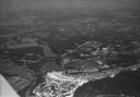
| Date: | 1930 |
|---|---|
| Description: | Aerial view of the town of Wisconsin Dells, the dam on the Wisconsin River, and the generating plant. The town of Wisconsin Dells was known as Kilbourn Cit... |
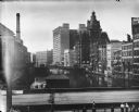
| Date: | |
|---|---|
| Description: | Elevated view of the Milwaukee commercial district looking north over the Milwaukee River from the Michigan Street bridge. Landmarks right to left: Pabst B... |
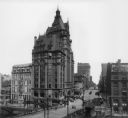
| Date: | 1903 |
|---|---|
| Description: | Elevated view from Wisconsin River looking east. The Pabst Building is on the northwest corner of N. Water Street and E. Wisconsin Avenue with the Mack bui... |
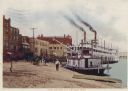
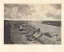
| Date: | 1904 |
|---|---|
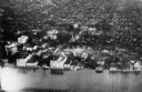
| Description: | Levee in harbor, with boats, horse-drawn carriages, and steamboats. Caption reads: "The Levee, La Crosse, Wis." |
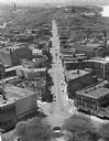
| Date: | 1927 |
|---|---|
| Description: | Elevated view looking east from the Wisconsin State Capitol down East Washington Avenue. |
| Date: | 1891 |
|---|---|
| Description: | View from corner of storefronts. Horse-drawn vehicles and pedestrians are in the street. There is a water fountain with a cup in the foreground. |
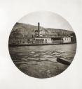
| Date: | 05 10 1894 |
|---|---|
| Description: | View of a ferry with the name Liberty from the Ohio River. A row of buildings in the background along a street near the river include a hotel. |

| Date: | |
|---|---|
| Description: | Aerial view of a developed strip of land on Barnegat Bay showing the Atlantic ocean, houses, lakes, railroad tracks, a marina and a jetty in the distance. |
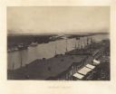
| Date: | 1866 |
|---|---|
| Description: | Elevated view over storefronts and the river. Plate 50 |
| Date: | 1866 |
|---|---|
| Description: | Elevated view over storefronts and the river. Plate 49 |

| Date: | |
|---|---|
| Description: | Elevated view of man filling a street sprinkler or "water wagon" pulled by two horses near the intersection of First and Main Streets. |

| Date: | 1954 |
|---|---|
| Description: | Elevated view from the Wisconsin State Capitol looking west up State Street toward the University of Wisconsin. Frozen Lake Monona is on the right. |
| Date: | 1959 |
|---|---|
| Description: | Elevated view of State Street from the Wisconsin State Capitol building. Lake Mendota is on the far right. |

| Date: | 1989 |
|---|---|
| Description: | This color coded map shows the various rivers, lakes, bays, and islands that make up the harbor. It includes an index of industries (maritime and non-marit... |
If you didn't find the material you searched for, our Library Reference Staff can help.
Call our reference desk at 608-264-6535 or email us at: