 Filter: Categories of Wisconsin Historical Images
Filter: Subject of Commercial buildings
Filter: Type of Map or Atlas
Filter: Year of 1900-1999
Filter: Categories of Wisconsin Historical Images
Filter: Subject of Commercial buildings
Filter: Type of Map or Atlas
Filter: Year of 1900-1999

| Date: | 1925 |
|---|---|
| Description: | Map produced by the Paul E. Stark Company to advertising sales and services. Bottom of the map features sales records for 1919 to 1925 and a paragraph read... |
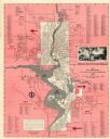
| Date: | 1954 |
|---|---|
| Description: | This map of Wausau is pink, red, gray, and white. The map includes indexes of streets, industries, and community buildings and features a photograph of the... |

| Date: | 1910 |
|---|---|
| Description: | A Sanborn insurance map of a section of Milwaukee, including East Clybourn and East Buffalo Streets. "Italian Section 3/4/30" is written on the page in blu... |

| Date: | 1910 |
|---|---|
| Description: | A Sanborn insurance map of Milwaukee, including the shore of Lake Michigan. |

| Date: | 12 1912 |
|---|---|
| Description: | Sanborn map of Sun Prairie, showing Main, Center and Church Streets. |

| Date: | 1900 |
|---|---|
| Description: | A Sanborn fire insurance map of Sauk City created in 1900. |

| Date: | 1915 |
|---|---|
| Description: | A Sanborn fire insurance map of Sauk City created in 1915. |
If you didn't find the material you searched for, our Library Reference Staff can help.
Call our reference desk at 608-264-6535 or email us at:


