 Filter: Categories of Wisconsin Historical Images
Filter: Subject of College buildings
Filter: Type of Map or Atlas
Filter: Categories of Wisconsin Historical Images
Filter: Subject of College buildings
Filter: Type of Map or Atlas

| Date: | 1912 |
|---|---|
| Description: | This manuscript blueprint map shows land conditions for future construction development on the University of Wisconsin-Madison campus. It highlights roads ... |

| Date: | 1905 |
|---|---|
| Description: | This blueprint map shows buildings and roads on Bascom Hill. University Avenue, Park street, Charter Street, and Lincoln Drive are labeled. Lake Mendota is... |
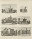
| Date: | 1878 |
|---|---|
| Description: | Six lithographs are grouped together showing mostly state normal schools. The scenes clockwise from top left are: State Normal School, Oshkosh; State Norma... |

| Date: | 1926 |
|---|---|
| Description: | This blueprint map is oriented with north to the upper left. The map shows buildings with note of those "to be torn down," sidewalks, proposed power plant,... |
If you didn't find the material you searched for, our Library Reference Staff can help.
Call our reference desk at 608-264-6535 or email us at: