 Filter: Categories of Wisconsin Historical Images
Filter: Subject of Clothing and dress
Filter: Year of 1700-1799
Filter: Subject of engraving
Filter: Categories of Wisconsin Historical Images
Filter: Subject of Clothing and dress
Filter: Year of 1700-1799
Filter: Subject of engraving
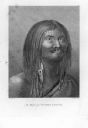
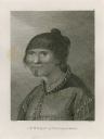
| Date: | 1784 |
|---|---|
| Description: | Plate 38. Portrait from Cook's Third Expedition, 1776-1779, while in Alaska. |
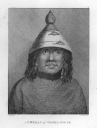
| Date: | 1784 |
|---|---|
| Description: | Plate 39. Portrait from Cook's Third Expedition, 1776-1779, while in Alaska. |

| Date: | 1784 |
|---|---|
| Description: | Plate 41. Scene from Cook's Third Expedition, 1776-1779, while in Alaska. |

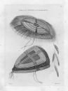
| Date: | 1784 |
|---|---|
| Description: | Plate 42. Scene from Cook's Third Expedition, 1776-1779, while in Alaska. |
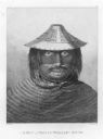
| Date: | 1784 |
|---|---|
| Description: | Plate 46. Portrait from Cook's Third Expedition, 1776-1779, while in Alaska. |

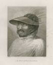
| Date: | 1784 |
|---|---|
| Description: | Plate 47. Portrait from Cook's Third Expedition, 1776-1779, while in Alaska. |
| Date: | 1784 |
|---|---|
| Description: | Plate 48. Portrait from Cook's Third Expedition, 1776-1779, while in Alaska. |
| Date: | 1784 |
|---|---|
| Description: | Plate 49. Portrait from Cook's Third Expedition, 1776-1779, while in Alaska. |

| Date: | 1784 |
|---|---|
| Description: | Plate 50. Portrait from Cook's Third Expedition, 1776-1779, while in Alaska. |
| Date: | 1784 |
|---|---|
| Description: | Plate 56. Drawing from Cook's Third Expedition, 1776-1779, while in Alaska. |

| Date: | 1784 |
|---|---|
| Description: | Plate 57. Scene from Cook's Third Expedition, 1776-1779, while in Alaska. |

| Date: | 1784 |
|---|---|
| Description: | Plate 58. Scene from Cook's Third Expedition, 1776-1779, while in Alaska. |

| Date: | 1786 |
|---|---|
| Description: | Portrait engraving of Thomas Jefferson, from the painting by M. Brown. |

| Date: | 1720 |
|---|---|
| Description: | Double hemispherical world map showing routes of Tasman, Magellan, Mendana, etc. Relief shown pictorially. Title in oak wreath cartouche. Map between four ... |

| Date: | 1712 |
|---|---|
| Description: | Engraved double-hemispherical world map by Moll, included in his atlas The world described, or, A new and correct sett of maps: shewing the kingdoms and st... |

| Date: | 1740 |
|---|---|
| Description: | Engraved and hand-colored map of the Iberian peninsula as a theater of war during the War of the Spanish Succession (1701-1714). The map is dedicated to Ki... |

| Date: | 1785 |
|---|---|
| Description: | Map of part of North America engraved and hand-colored (the light brown design is a superposition of the map and cartouche derived from the oxidation of th... |

| Date: | 1790 |
|---|---|
| Description: | An updated and corrected version of Robert de Vaugondy's 1750 map "Amérique Septentrionale: Dressée sur les Relations les Plus Modernes des Voyageurs et Na... |

| Date: | 1746 |
|---|---|
| Description: | Detailed map of the western hemisphere and part of Africa and Europe. Islands, cities, settlements, rivers, lakes, countries, and regions are marked. Mount... |

| Date: | 1780 |
|---|---|
| Description: | Map of North and South America, showing the boundaries of colonial territories, cities, settlements, rivers, lakes, and Native American land. Particular em... |
If you didn't find the material you searched for, our Library Reference Staff can help.
Call our reference desk at 608-264-6535 or email us at: