 Filter: Categories of Wisconsin Historical Images
Filter: Subject of Clothing and dress
Filter: Subject of superior, lake
Filter: Subject of lakes
Filter: Categories of Wisconsin Historical Images
Filter: Subject of Clothing and dress
Filter: Subject of superior, lake
Filter: Subject of lakes

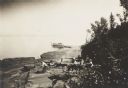
| Date: | 1905 |
|---|---|
| Description: | Camp Stella looking south toward the Bayfield County shoreline from an Apostle Island. |
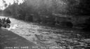
| Date: | 1931 |
|---|---|
| Description: | View of the Squaw Bay Caves, near Cornucopia, with people in a boat off to the far left. The caves were renamed Mawikwe Bay, and Mawikwe is Ojibwe for weep... |
| Date: | 1912 |
|---|---|
| Description: | Picnic party on the rocks along the shore, among the Apostle Islands in Lake Superior. |

| Date: | 1676 |
|---|---|
| Description: | Detailed map of North and South America. Cities, towns, forests, and mountains are shown pictorially. Duval labels regions, islands, cities, lakes, and Nat... |

| Date: | 1683 |
|---|---|
| Description: | Map of the north east coast of North America showing islands, regions, Native American land, bays, and a few European settlements. The Great Lakes appear i... |

| Date: | 1963 |
|---|---|
| Description: | Text on front reads: "Wisconsin's North Coast." A man is standing on the side deck of a boat, and in the distance is the Raspberry Island Lighthouse with a... |
If you didn't find the material you searched for, our Library Reference Staff can help.
Call our reference desk at 608-264-6535 or email us at: