 Filter: Categories of Wisconsin Historical Images
Filter: Subject of Clothing and dress
Filter: Subject of ships
Filter: Subject of land use
Filter: Categories of Wisconsin Historical Images
Filter: Subject of Clothing and dress
Filter: Subject of ships
Filter: Subject of land use

| Date: | 1886 |
|---|---|
| Description: | Cover of an advertising brochure for the Milwaukee Harvester Company featuring a color chromolithograph illustration of a farmer in a field operating a hor... |

| Date: | 1913 |
|---|---|
| Description: | Seven men are holding the original flag from Perry's Victory. The men are standing on the flagship "Niagara" to celebrate the centennial of the victory. Th... |

| Date: | 1917 |
|---|---|
| Description: | World War I poster urging newly arrived immigrants to conserve food to aid the allied cause. People in ethnic costume being ushered into the United States ... |
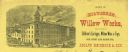
| Date: | |
|---|---|
| Description: | Letterhead of the Milwaukee Willow Works, a manufacturer of children's carriages, willow ware, and toys, with a three-quarter view of the company building,... |

| Date: | 1856 |
|---|---|
| Description: | " . . . The first in their series was not an 'improvement' but a view of the Green Bay settlement, looking downstream. From a simulated rustic fence corner... |

| Date: | 1970 |
|---|---|
| Description: | Elevated view of an International Harvester model MA-1500 Metro delivery truck is parked on a bridge overlooking a body of water and a city skyline, likely... |

| Date: | 1874 |
|---|---|
| Description: | Bird's-eye view map of Appleton, Wisconsin. Map reads: "NOTE.-Since the above cut was engraved, the Fox River Pulp & Paper Co.'s Mammoth Mills have been er... |
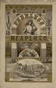
| Date: | 1880 |
|---|---|
| Description: | Catalog cover with gold and black ink illustrations. In the center a woman standing on a globe of the earth carries a sheaf of wheat on her shoulder and a ... |

| Date: | 1755 |
|---|---|
| Description: | Map of Virginia and parts of Maryland, North Carolina, and New Jersey. It shows borders, boundary lines, some Native American land, counties, cities, towns... |
If you didn't find the material you searched for, our Library Reference Staff can help.
Call our reference desk at 608-264-6535 or email us at: