 Filter: Categories of Wisconsin Historical Images
Filter: Subject of Clothing and dress
Filter: Subject of ocean
Filter: Subject of signs and symbols
Filter: Categories of Wisconsin Historical Images
Filter: Subject of Clothing and dress
Filter: Subject of ocean
Filter: Subject of signs and symbols
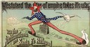
| Date: | 1886 |
|---|---|
| Description: | Advertisement for the Atchison, Topeka and Santa Fe Railroad featuring an illustration of Uncle Sam stretched from the Missouri River to the Pacific Ocean.... |
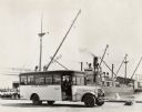
| Date: | 06 03 1925 |
|---|---|
| Description: | International "outer harbor" bus parked near a large boat and several harbor buildings. The bus was built on an International model 52 or model 53 chassis. |
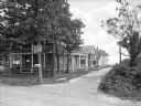
| Date: | |
|---|---|
| Description: | View from unpaved road toward houses down a side dirt road leading toward a beach in the background. A man stands on the porch of the house in the left for... |
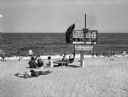
| Date: | 1915 |
|---|---|
| Description: | An elevated lifeguard station stands on the sand at Wriests Beach while people sunbathe on the beach and wade in the water. The sign on the lifeguard stati... |

| Date: | 1915 |
|---|---|
| Description: | View along boardwalk, with people sitting, and other people walking. Buildings are along the left, and on the right is a lifeguard tower that looks down o... |
| Date: | |
|---|---|
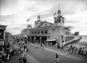
| Description: | Crowds walk along the boardwalk at Funchase amusement pier. A building with flags flying from its turrets features a sign that reads "Funchase Skating". T... |
| Date: | 1920 |
|---|---|
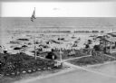
| Description: | Elevated view of the Dipsy Baths outbuilding and surrounding beach. Umbrellas are set up in the sand where people sunbathe or wade in the water, and an Ame... |
| Date: | 06 1945 |
|---|---|
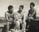
| Description: | Micronesian men, who put thatched roofs on buildings in the western Caroline Islands for United States forces, sit chatting with Robert J. Doyle, The Journ... |

| Date: | 1720 |
|---|---|
| Description: | Double hemispherical world map showing routes of Tasman, Magellan, Mendana, etc. Relief shown pictorially. Title in oak wreath cartouche. Map between four ... |

| Date: | 1740 |
|---|---|
| Description: | From Weigel's Atlas portatilis, oder, Compendieuse Vorstellung der gantzen Welt. Map of Europe. |

| Date: | 1712 |
|---|---|
| Description: | Engraved double-hemispherical world map by Moll, included in his atlas The world described, or, A new and correct sett of maps: shewing the kingdoms and st... |
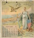
| Date: | 1893 |
|---|---|
| Description: | Calendar front, with the month of January, 1893. At the top it reads: "1893 calendar presented to the farmers of the world with the compliments of Aultman,... |

| Date: | 03 24 1950 |
|---|---|
| Description: | Front cover of a farewell dinner menu from the Italian Line ship Saturnia, with two Commedia dell' Arte characters: Tartaglia, a rotund figure who w... |
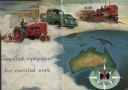
| Date: | 1955 |
|---|---|
| Description: | Men are driving International Harvester tractor, truck and crawler in a cloud above the continent of Australia. The IH logo is at the bottom right in a com... |
If you didn't find the material you searched for, our Library Reference Staff can help.
Call our reference desk at 608-264-6535 or email us at: