 Filter: Categories of Wisconsin Historical Images
Filter: Subject of Clothing and dress
Filter: Subject of islands
Filter: Subject of cities and towns
Filter: Categories of Wisconsin Historical Images
Filter: Subject of Clothing and dress
Filter: Subject of islands
Filter: Subject of cities and towns

| Date: | |
|---|---|
| Description: | Elevated view from railing of immigrants boarding a ferry to depart Ellis Island. |

| Date: | 1852 |
|---|---|
| Description: | Illustration of four Indians on Madeline Island with a canoe in the water on the shore. |
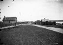
| Date: | 1910 |
|---|---|
| Description: | Looking down La Pointe's main street on Madeline Island. A man is walking on the board sidewalk on the left, and another person is driving a horse-drawn ve... |
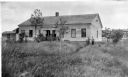
| Date: | 1910 |
|---|---|
| Description: | George F. Thomas is holding a child and standing next to Edward F. Hansen in front of Treaty Hall in La Pointe on Madeline Island. |

| Date: | 1905 |
|---|---|
| Description: | Camp Stella looking south toward the Bayfield County shoreline from an Apostle Island. |
| Date: | 1910 |
|---|---|
| Description: | View from pier towards the Old Mission in La Pointe on Madeline Island. Men are sitting at the shoreline. Caption reads: "Apostle Islands, Wis. Madeline Is... |
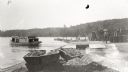
| Date: | 1929 |
|---|---|
| Description: | One of the four harbors on Washington Island. There is a man on a pier or dock in the foreground, and a boat approaching on the left. A tree-lined shorelin... |

| Date: | 10 28 1938 |
|---|---|
| Description: | Man inspecting fish hung up to dry in a yard on Jones Island. |

| Date: | 05 13 1950 |
|---|---|
| Description: | More than 150 Madison high school pupils recruited through the Madison Youth Council helped plant trees and shrubs on the Vilas Park island. |

| Date: | 05 13 1950 |
|---|---|
| Description: | Three teenage girls are carrying shovels on their shoulders while crossing a wooden foot bridge. More than 150 Madison high school pupils recruited throug... |

| Date: | 08 18 1963 |
|---|---|
| Description: | Two children stand on an outdoor stairway of wood-shingle house. Caption on back of print reads, "Back steps in 'Goosetown.' a section around Broadway and ... |

| Date: | 1898 |
|---|---|
| Description: | View across road of Syl standing in front of a three-story duplex house on Jones Island. |
| Date: | 1915 |
|---|---|
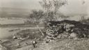
| Description: | Elevated view of the Mississippi River from a bluff. There is a farm and other houses along the shoreline, and in the foreground a boy stands on the bluff ... |

| Date: | 1712 |
|---|---|
| Description: | Engraved double-hemispherical world map by Moll, included in his atlas The world described, or, A new and correct sett of maps: shewing the kingdoms and st... |

| Date: | 03 24 1950 |
|---|---|
| Description: | Front cover of a farewell dinner menu from the Italian Line ship Saturnia, with two Commedia dell' Arte characters: Tartaglia, a rotund figure who w... |
| Date: | 1931 |
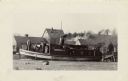
|---|---|
| Description: | The Frank Braeger is moored on the shore of Jones Island with steam issuing from the pipe, with the crew posing on the boat. In the background a man... |

| Date: | 1627 |
|---|---|
| Description: | Map of North and South America showing settlements, rivers, lakes, mountains, islands and regions of the western hemisphere. It includes an inset map of Gr... |

| Date: | 1630 |
|---|---|
| Description: | One of the few maps by Dutch cartographer Willem Blaeu depicting the Americas, this map shows regions, settlements, islands, mountains, forests, rivers, an... |

| Date: | 1676 |
|---|---|
| Description: | Detailed map of North and South America. Cities, towns, forests, and mountains are shown pictorially. Duval labels regions, islands, cities, lakes, and Nat... |

| Date: | 1746 |
|---|---|
| Description: | Detailed map of the western hemisphere and part of Africa and Europe. Islands, cities, settlements, rivers, lakes, countries, and regions are marked. Mount... |
If you didn't find the material you searched for, our Library Reference Staff can help.
Call our reference desk at 608-264-6535 or email us at: