 Filter: Categories of Wisconsin Historical Images
Filter: Subject of Clothing and dress
Filter: Subject of cities and towns
Filter: Subject of tobacco
Filter: Categories of Wisconsin Historical Images
Filter: Subject of Clothing and dress
Filter: Subject of cities and towns
Filter: Subject of tobacco
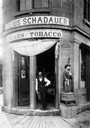
| Date: | 1880 |
|---|---|
| Description: | A man posing in the open doorway of Julius Schadauer's tobacco shop at 101 State Street. The sign above the doorway reads: "Schadauer of Cigars Fact. No 62... |

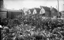
| Date: | 1895 |
|---|---|
| Description: | Looking down one of Whitehall's streets with horses, carriages, men and stores. A wagon is unloading tobacco. Caption at bottom reads: "Delivering Tobacco ... |
| Date: | |
|---|---|
| Description: | View from street towards a man standing in front of the doorway to the Julius Schadauer's tobacco store on a street corner at 101 State Street. A man is on... |
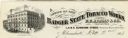
| Date: | |
|---|---|
| Description: | Letterhead of the Badger State Tobacco Works of Milwaukee, Wisconsin, with a three-quarter view of the building, men working on boats moored near the water... |

| Date: | |
|---|---|
| Description: | Letterhead of Louis Koenig, dealer in "Fine Wines, Liquors and Cigars" from Scott, Wisconsin, with a drawing of two men wearing long-sleeved shirts, vests,... |
| Date: | 09 27 1895 |
|---|---|
| Description: | A plot of land in front of a row of houses features cabbage in the foreground, ripe, four-foot tall Havana seed leaf tobacco plants in the center, and swee... |

| Date: | |
|---|---|
| Description: | View across unpaved road of the front of a brick two-story tobacco warehouse. Three men are posed standing on the stoop in front of the door. A barefoot gi... |
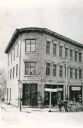
| Date: | |
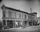
|---|---|
| Description: | View across East Main Street towards a row of businesses, looking southeast. From the left, the corner building has a tobacco shop with a law office above,... |

| Date: | 1755 |
|---|---|
| Description: | Map of Virginia and parts of Maryland, North Carolina, and New Jersey. It shows borders, boundary lines, some Native American land, counties, cities, towns... |
If you didn't find the material you searched for, our Library Reference Staff can help.
Call our reference desk at 608-264-6535 or email us at: