 Filter: Categories of Wisconsin Historical Images
Filter: Subject of Clothing and dress
Filter: Subject of bays
Filter: Subject of lakes
Filter: Categories of Wisconsin Historical Images
Filter: Subject of Clothing and dress
Filter: Subject of bays
Filter: Subject of lakes
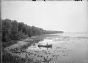
| Date: | 1900 |
|---|---|
| Description: | Slightly elevated view of the west shore of Turville Bay. Two men sit in a rowboat near the shore surrounded by water lilies. There is a fence in the foreg... |
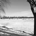
| Date: | 01 2014 |
|---|---|
| Description: | View from shoreline on a sunny day of snow-covered, frozen Monona Bay. People in the distance are standing or sitting near ice fishing holes and ice fishin... |

| Date: | 1683 |
|---|---|
| Description: | Map of the north east coast of North America showing islands, regions, Native American land, bays, and a few European settlements. The Great Lakes appear i... |

| Date: | 1755 |
|---|---|
| Description: | Map of Virginia and parts of Maryland, North Carolina, and New Jersey. It shows borders, boundary lines, some Native American land, counties, cities, towns... |
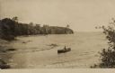
| Date: | 08 18 1909 |
|---|---|
| Description: | Text on front reads: "Lake Court Oreilles, Reserve Wis." A man in a rowboat looks out over the lake from a tree lined bay. |
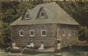
| Date: | 1907 |
|---|---|
| Description: | Text on front reads: "Donges Bay Boat House." A man rowing a boat with two women passengers, in front of a boathouse built of rocks. A lawn jockey stands o... |
If you didn't find the material you searched for, our Library Reference Staff can help.
Call our reference desk at 608-264-6535 or email us at: