 Filter: Categories of Wisconsin Historical Images
Filter: Subject of Clothing and dress
Filter: Subject of african americans
Filter: Subject of islands
Filter: Categories of Wisconsin Historical Images
Filter: Subject of Clothing and dress
Filter: Subject of african americans
Filter: Subject of islands
| Date: | |
|---|---|
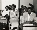
| Description: | Wadmalaw Island Citizenship group participants in the midst of a session. |
| Date: | |
|---|---|
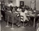
| Description: | Mrs. Brewer teaching a citizenship class at Edisto Island. Septima Clark, far left. |
| Date: | |
|---|---|
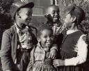
| Description: | Family on Sea Island that was part of the Citizenship group that took place on the island. |

| Date: | |
|---|---|
| Description: | A group of African American boys wearing hats on Johns Island. |

| Date: | 1755 |
|---|---|
| Description: | Map of Virginia and parts of Maryland, North Carolina, and New Jersey. It shows borders, boundary lines, some Native American land, counties, cities, towns... |
If you didn't find the material you searched for, our Library Reference Staff can help.
Call our reference desk at 608-264-6535 or email us at: