Filter: Categories of Wisconsin Historical Images
Filter: Subject of City halls
Filter: Year of 1900-1999
Filter: Categories of Wisconsin Historical Images
Filter: Subject of City halls
Filter: Year of 1900-1999
| Date: | 03 31 1954 |
|---|---|
| Description: | City Inspection Superintendent Ray Burt handing the key to City Hall to Merrill Hays, who represents an investment group that purchased the building. Willi... |

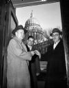
| Date: | 03 31 1954 |
|---|---|
| Description: | City Inspection Superintendent Ray Burt hands the key to City Hall to Merrill Haley, representing the investment group that purchased the building. William... |
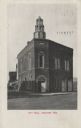
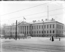
| Date: | 07 1911 |
|---|---|
| Description: | Exterior view of the front entrance on a corner of the two-story brick City Hall. A horse-drawn wagon is visible on the far left. Caption reads: "City Hall... |
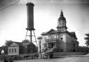
| Date: | 1910 |
|---|---|
| Description: | View of Athens City Hall, built in 1903-1904, featuring a central dome and clock tower. A water tower can be seen beyond the city jail to the left. |

| Date: | 1957 |
|---|---|
| Description: | Large Letter style postcard for Green Bay depicting various scenes in the letters that spell the name of the city. Caption reads: "Greetings from Green Bay... |

| Date: | 1909 |
|---|---|
| Description: | A map of Langlade County, Wisconsin that shows townships and ranges, towns, cities and villages, wagon roads, churches, schools, sawmills, town halls, chee... |

| Date: | 1926 |
|---|---|
| Description: | A map of Lincoln County, Wisconsin that shows the township and range grid, towns, cities and villages, lakes and streams, residences, churches, school hous... |

| Date: | 1903 |
|---|---|
| Description: | This 1903 map of Outagamie County, Wisconsin, shows the township and range grid, towns, sections, cities and villages, landownership and acreages, rural ma... |

| Date: | 1922 |
|---|---|
| Description: | This map of Outagamie County, Wisconsin, from the first half of the 20th century, shows the township and range grid, towns, sections, cities and villages, ... |

| Date: | 1913 |
|---|---|
| Description: | This 1913 map of Pepin County, Wisconsin, shows the township and range grid, towns, villages, rural routes, railroads, roads, schools, churches, cemeteries... |

| Date: | 1922 |
|---|---|
| Description: | This map of Pierce County, Wisconsin, from the first half of the 20th century, shows the township and range grid, towns, sections, villages, roads, railroa... |

| Date: | 1914 |
|---|---|
| Description: | This 1914 map of Price County, Wisconsin, shows land for sale by the Good Land Company and Dewitt van Ostrand of Phillips. Also shown are the township and ... |

| Date: | 1920 |
|---|---|
| Description: | This map shows the township and range system, sections, schools, churches, cemeteries, town halls, roads, railroads, and lakes and streams in Shawano Count... |

| Date: | 1917 |
|---|---|
| Description: | This 1917 map of Ashland County, Wisconsin, shows the township and range system, towns, sections, cities and villages, the Bad River Indian Reservation, ra... |

| Date: | 1918 |
|---|---|
| Description: | This 1918 map of Chippewa County, Wisconsin, shows the township and range grid, towns, sections, cities and villages, rural residences, churches, schools, ... |

| Date: | 1914 |
|---|---|
| Description: | Map shows school houses, creameries, post offices, saw mills, grist mills, churches, cemeteries, town halls, stores, roads, state roads, and railroads. "Co... |
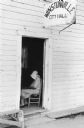
| Date: | 04 1965 |
|---|---|
| Description: | A woman wearing a bonnet sits inside the open doorway of a building. A sign above the doorway reads "Winstonville City Hall." |
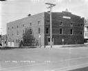
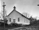
| Date: | 1929 |
|---|---|
| Description: | View from street of City Hall building on a corner. There are garages in the back on the left. On the corner there is a stop sign, a Hwy 51 signpost, and a... |
| Date: | 1918 |
|---|---|
| Description: | Exterior of the governor general's house of the U.S. Army's North Russian Expeditionary Force. |
If you didn't find the material you searched for, our Library Reference Staff can help.
Call our reference desk at 608-264-6535 or email us at: