 Filter: Categories of Wisconsin Historical Images
Filter: Subject of City halls
Filter: Subject of transportation
Filter: Categories of Wisconsin Historical Images
Filter: Subject of City halls
Filter: Subject of transportation

| Date: | 1913 |
|---|---|
| Description: | This 1913 map of Pepin County, Wisconsin, shows the township and range grid, towns, villages, rural routes, railroads, roads, schools, churches, cemeteries... |

| Date: | 1922 |
|---|---|
| Description: | This map of Pierce County, Wisconsin, from the first half of the 20th century, shows the township and range grid, towns, sections, villages, roads, railroa... |

| Date: | |
|---|---|
| Description: | This map from the early 20th century shows the township and range grid, towns, sections, cities and villages, railroads, roads, schools, churches, cemeteri... |

| Date: | 1914 |
|---|---|
| Description: | This 1914 map of Price County, Wisconsin, shows land for sale by the Good Land Company and Dewitt van Ostrand of Phillips. Also shown are the township and ... |

| Date: | 1920 |
|---|---|
| Description: | This map shows the township and range system, sections, schools, churches, cemeteries, town halls, roads, railroads, and lakes and streams in Shawano Count... |

| Date: | 1917 |
|---|---|
| Description: | This 1917 map of Ashland County, Wisconsin, shows the township and range system, towns, sections, cities and villages, the Bad River Indian Reservation, ra... |

| Date: | 1918 |
|---|---|
| Description: | This 1918 map of Chippewa County, Wisconsin, shows the township and range grid, towns, sections, cities and villages, rural residences, churches, schools, ... |

| Date: | 1914 |
|---|---|
| Description: | Map shows school houses, creameries, post offices, saw mills, grist mills, churches, cemeteries, town halls, stores, roads, state roads, and railroads. "Co... |

| Date: | |
|---|---|
| Description: | Elevated view of Cassville, including the town hall and St. Peter's Church. |
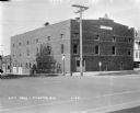
| Date: | 1929 |
|---|---|
| Description: | View from street of City Hall building on a corner. There are garages in the back on the left. On the corner there is a stop sign, a Hwy 51 signpost, and a... |

| Date: | 1912 |
|---|---|
| Description: | View across street of the Sun Prairie City Hall, a large brick building with two balconies in the tower and arched windows on the ground floor. A person dr... |

| Date: | 1912 |
|---|---|
| Description: | View down Main Street. On the left is a bowling alley/billiard parlor, a real estate/insurance business, and a livery/garage. On the next block is City Hal... |

| Date: | 1912 |
|---|---|
| Description: | View down Main Street, with City Hall in the background. On the left is a general merchandise store, a bank and other businesses. In the foreground on the ... |

| Date: | 1913 |
|---|---|
| Description: | View from across street of the Village Hall/Fire Station. There are hitching posts along the curb. On the right a young boy stands on the sidewalk near a f... |
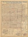
| Date: | 1890 |
|---|---|
| Description: | The map shows roads and railroads, houses, schools, town halls, and other points of interest in parts of Shawano, Oconto, and Brown counties. The lower lef... |
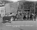
| Date: | 10 24 1930 |
|---|---|
| Description: | A line of clowns and assorted pantomime animals dressed up for Cheese Day. The animals include; a horse, a woodchuck, a bear, a giraffe and an elephant. A ... |
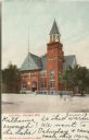
| Date: | 1906 |
|---|---|
| Description: | Colorized postcard of an exterior view of City Hall, a brick building with an arched entrance, a flag pole on the left, and a belfry on the right. Caption ... |

| Date: | 1909 |
|---|---|
| Description: | Colorized postcard view down the unpaved street, with the city hall building on the corner on the right. Caption reads: "City Hall and Spring Street, Beave... |

| Date: | 05 1999 |
|---|---|
| Description: | An addition was made to the hall to accommodate additional offices. |

| Date: | |
|---|---|
| Description: | Exterior view from street of Hillsboro's City Hall. It was constructed in 1937 with assistance from a Works Progress Administration (WPA) project. The lowe... |
If you didn't find the material you searched for, our Library Reference Staff can help.
Call our reference desk at 608-264-6535 or email us at: