Filter: Categories of Wisconsin Historical Images
Filter: Subject of City halls
Filter: Subject of transportation
Filter: Categories of Wisconsin Historical Images
Filter: Subject of City halls
Filter: Subject of transportation
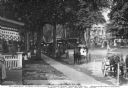
| Date: | 09 01 1908 |
|---|---|
| Description: | View from lawn toward the street where a trolley runs, and horse-drawn vehicles parked along the curbs. People stand on the lawns and on porches, facing to... |
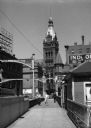
| Date: | 1936 |
|---|---|
| Description: | View from bridge of City Hall at North Water, North Market, and East Wells Streets, and East Kilbourn Avenue. |
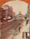
| Date: | 1870 |
|---|---|
| Description: | Stereograph; view of the earlier City Hall building, on Market Square at the corner of E. Water Street and Oneida Street. Several signs are in the image, i... |
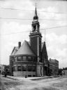
| Date: | 1910 |
|---|---|
| Description: | A view of the facade and side of City Hall. The main entrance is part of the bell tower. Men are sitting on the bench outside to the right. |

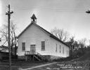
| Date: | |
|---|---|
| Description: | Exterior view of the city hall, a brick building built in 1817. A man and young boy stand in the main doorway of the building. An automobile is near a smal... |
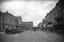
| Date: | |
|---|---|
| Description: | View of Flores Avenue, a commercial section of downtown. The city hall, built in 1884, stands on the left near Laredo National Bank, founded in 1892. On ... |
| Date: | |
|---|---|
| Description: | View of downtown looking toward Hotel de Francia. The city hall, built in 1884, is at right. |

| Date: | |
|---|---|
| Description: | Colorized view of the old three-story, red brick city hall and firehouse. View of the building's exterior includes a team of horse-drawn fire wagons and fi... |
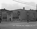
| Date: | 1927 |
|---|---|
| Description: | The exterior of the city hall and public library on the corner of East Bluff Street and Wisconsin Avenue. There is a toy wagon outside the building. The la... |

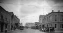
| Date: | |
|---|---|
| Description: | View down Main Street from City Hall featuring horses and wagons, automobiles, and street cars. Stores line either side of the street. |
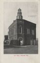
| Date: | 07 1911 |
|---|---|
| Description: | Exterior view of the front entrance on a corner of the two-story brick City Hall. A horse-drawn wagon is visible on the far left. Caption reads: "City Hall... |
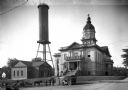
| Date: | 1910 |
|---|---|
| Description: | View of Athens City Hall, built in 1903-1904, featuring a central dome and clock tower. A water tower can be seen beyond the city jail to the left. |
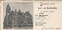
| Date: | |
|---|---|
| Description: | Letterhead of the City of Oshkosh, Comptroller's Office, with a three-quarter view of the city hall, people standing or walking by the building, and a hors... |

| Date: | |
|---|---|
| Description: | Letterhead of the City of Superior, Wisconsin, with a three-quarter view of City Hall, printed in blue-green ink, with additional text in brown ink, by Typ... |

| Date: | 1909 |
|---|---|
| Description: | A map of Langlade County, Wisconsin that shows townships and ranges, towns, cities and villages, wagon roads, churches, schools, sawmills, town halls, chee... |

| Date: | 1926 |
|---|---|
| Description: | A map of Lincoln County, Wisconsin that shows the township and range grid, towns, cities and villages, lakes and streams, residences, churches, school hous... |

| Date: | 1903 |
|---|---|
| Description: | This 1903 map of Outagamie County, Wisconsin, shows the township and range grid, towns, sections, cities and villages, landownership and acreages, rural ma... |

| Date: | |
|---|---|
| Description: | This 1907 map of Outagamie County, Wisconsin, shows the township and range grid, towns, sections, cities and villages, railroads, wagon roads, churches, sc... |

| Date: | 1922 |
|---|---|
| Description: | This map of Outagamie County, Wisconsin, from the first half of the 20th century, shows the township and range grid, towns, sections, cities and villages, ... |
If you didn't find the material you searched for, our Library Reference Staff can help.
Call our reference desk at 608-264-6535 or email us at: