 Filter: Categories of Wisconsin Historical Images
Filter: Subject of City halls
Filter: Subject of rivers
Filter: Categories of Wisconsin Historical Images
Filter: Subject of City halls
Filter: Subject of rivers

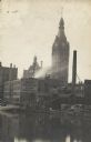
| Date: | 08 23 1913 |
|---|---|
| Description: | Elevated view looking east from W. Wells street across the Milwaukee River. The E. Wells power plant (with arrow), Pabst Theater, and City Hall are on the ... |
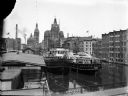
| Date: | |
|---|---|
| Description: | Elevated view of two Goodrich Line passenger ferries docked on the west bank of the Milwaukee River, north of the Clybourn Street bridge. The Pabst buildin... |

| Date: | 1922 |
|---|---|
| Description: | Aerial view of downtown with City Hall and Milwaukee River. |

| Date: | 1947 |
|---|---|
| Description: | City Hall near the Milwaukee River. |
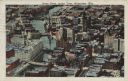
| Date: | 1925 |
|---|---|
| Description: | Downtown aerial view with the Milwaukee River and City Hall. Caption reads: "Downtown Aerial View, Milwaukee, Wis." |

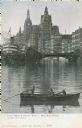
| Date: | |
|---|---|
| Description: | Color view from the river. Foreground has three people in a boat. A bridge over the river, and a boat to the left are in the center. City Hall is in the ... |
| Date: | |
|---|---|
| Description: | Hand-colored view from the water. Buildings are in the background, a boat and bridge are in the center. A small boat with people in it are in the foregroun... |
| Date: | 1900 |
|---|---|
| Description: | View across river of a boat docked near a building with a sign for Adolph Meinecke & Sons (Manufacturers). In the background is City Hall. |

| Date: | 1910 |
|---|---|
| Description: | Elevated view of downtown. Part of the Milwaukee River is on the left side. Sign for the Germania building is in the lower right, and city hall is in the b... |

| Date: | 1957 |
|---|---|
| Description: | Large Letter style postcard for Green Bay depicting various scenes in the letters that spell the name of the city. Caption reads: "Greetings from Green Bay... |

| Date: | 1909 |
|---|---|
| Description: | A map of Langlade County, Wisconsin that shows townships and ranges, towns, cities and villages, wagon roads, churches, schools, sawmills, town halls, chee... |

| Date: | 1913 |
|---|---|
| Description: | This 1913 map of Pepin County, Wisconsin, shows the township and range grid, towns, villages, rural routes, railroads, roads, schools, churches, cemeteries... |

| Date: | 1920 |
|---|---|
| Description: | This map shows the township and range system, sections, schools, churches, cemeteries, town halls, roads, railroads, and lakes and streams in Shawano Count... |

| Date: | 1911 |
|---|---|
| Description: | This map shows ward numbers, streets, railroads, electric car lines, parks, steam railways, section numbers, Lake Michigan and one mile concentric circles ... |

| Date: | 1912 |
|---|---|
| Description: | This map shows ward numbers, streets, railroads, electric car lines, parks, steam railways, section numbers, Lake Michigan and one mile concentric circles ... |

| Date: | |
|---|---|
| Description: | View of the Municipal Building (City Hall), and a bridge lined with street lamps crossing the Fox River. Automobiles are driving along the street. Caption ... |
If you didn't find the material you searched for, our Library Reference Staff can help.
Call our reference desk at 608-264-6535 or email us at:

