 Filter: Categories of Wisconsin Historical Images
Filter: Subject of Cities and towns
Filter: Subject of voting
Filter: Categories of Wisconsin Historical Images
Filter: Subject of Cities and towns
Filter: Subject of voting
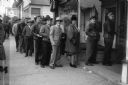
| Date: | 12 1946 |
|---|---|
| Description: | Members of the United Automobile Workers union, Local 75, line up outside the local's headquarters, 308 E. Center Street, to vote on delegates to the union... |

| Date: | 1950 |
|---|---|
| Description: | For a 1950 election, the United Packinghouse Workers Union sponsored a free bus to transport people to the voter registration site. |
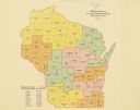
| Date: | 1922 |
|---|---|
| Description: | A map of Wisconsin showing the state’s congressional districts, it also provides the population total for the state, each district and each county. |

| Date: | 1898 |
|---|---|
| Description: | A hand-colored, cloth mounted map of Wisconsin showing the state’s congressional districts. The map also shows the counties, cities, towns, villages, river... |

| Date: | 11 03 1992 |
|---|---|
| Description: | "Poll workers front to back: Lester Unglaub, Millie Leichtle, Evangeline Koll, and Ethel Rahjes." |

| Date: | 01 01 1935 |
|---|---|
| Description: | This 1935 map of Walworth County, Wisconsin, shows the township and range grid, towns, sections, cities and villages, highways and roads, railroads, school... |
| Date: | 1964 |
|---|---|
| Description: | Two men holding protest signs are walking down a sidewalk past a white police officer who is holding a bullhorn at a Greenwood Freedom Day. In the backgrou... |

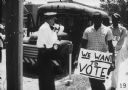
| Date: | 1964 |
|---|---|
| Description: | A long line of protesters standing on a sidewalk hold signs calling for voting rights and civil rights. One sign reads, "We Are Not Allowed to Vote". |

| Date: | 1964 |
|---|---|
| Description: | View down sidewalk of two male protestors wearing signs around their necks walking down a sidewalk in a Freedom Summer civil rights demonstration. The sign... |

| Date: | 1964 |
|---|---|
| Description: | View towards sidewalk of a line of demonstrators carrying signs during a Freedom Summer civil rights demonstration. A man walking along the sidewalk holds ... |

| Date: | 1961 |
|---|---|
| Description: | Shows wards and voting precincts. Published in The Capital times: January 28, 1961. |

| Date: | 1962 |
|---|---|
| Description: | This map shows the voting districts of Waukesha in red ink for the year 1962. The bottom of the map includes an index of streets. |

| Date: | 08 08 1960 |
|---|---|
| Description: | Philip Kuehn, left, Republican candidate for governor, chats in Ripon with Harry Dunbar, who will be 92 years old by the time he votes this fall. Dunbar, a... |

| Date: | 1945 |
|---|---|
| Description: | This map shows wards and precincts and includes a list of polling places by ward and precinct. The map reads: "Keep this Map . . . It Gives the Location of... |

| Date: | 1948 |
|---|---|
| Description: | This map shows wards and precincts and includes a list of polling places by ward and precinct. The map reads: "Keep this Map . . . It Gives the Location of... |

| Date: | 1955 |
|---|---|
| Description: | This map shows wards and precincts and includes list of polling places by ward and precinct, and list of State Assembly districts. |

| Date: | 1962 |
|---|---|
| Description: | A door hanger encouraging voters to vote down the plan to discontinue plans for creation of the Monona Terrace. |
| Date: | 1963 |
|---|---|
| Description: | Nathaniel Smith and Ernest Morgan enter the St. Francisville courthouse to vote. Three white men are sitting on a porch railing outside of the courthouse. |

| Date: | 1956 |
|---|---|
| Description: | This maps shows voting precincts and polling places as well as wards. Streets and the Sheboygan River are labeled. The bottom right of the map features a l... |

| Date: | 1948 |
|---|---|
| Description: | This map shows a list of polling places by ward and precinct in the left margin, a list of assembly districts, and additional handwritten notes. Lake Michi... |
If you didn't find the material you searched for, our Library Reference Staff can help.
Call our reference desk at 608-264-6535 or email us at: