 Filter: Categories of Wisconsin Historical Images
Filter: Subject of Cities and towns
Filter: Subject of forest conservation
Filter: Categories of Wisconsin Historical Images
Filter: Subject of Cities and towns
Filter: Subject of forest conservation

| Date: | 1935 |
|---|---|
| Description: | Two hand-colored maps of the area comprising the town of Millston (Plats of Townships 20 and 21 north, range 2 west), Jackson County, Wisconsin, showing 40... |
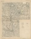
| Date: | 1941 |
|---|---|
| Description: | This map covers the area of Lincoln and Oneida counties, and part of Marathon county and includes a location map and legend. The bottom left margin reads: ... |

| Date: | 1898 |
|---|---|
| Description: | This map shows the conditions of the forest. Includes a color legend in left margin, depicting the various conditions. Original caption reads, "Compiled by... |
If you didn't find the material you searched for, our Library Reference Staff can help.
Call our reference desk at 608-264-6535 or email us at: