Filter: Categories of Wisconsin Historical Images
Filter: Subject of Cities and towns
Filter: Subject of deserts
Filter: Categories of Wisconsin Historical Images
Filter: Subject of Cities and towns
Filter: Subject of deserts
| Date: | |
|---|---|
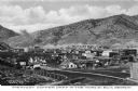
| Description: | Elevated view of a copper mining camp with desert hills in the background. Caption reads: "Greatest Copper Camp in the World, Ely, Nevada." |
| Date: | |
|---|---|
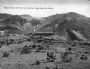
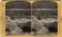
| Description: | Distant view of a mining operation and surrounding desert hills. Caption reads: "Mining Scene, Near Mojave, Cal." |
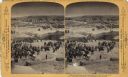
| Date: | 1893 |
|---|---|
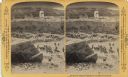
| Description: | A group of men in robes standing on a rock are facing to the left, perhaps in prayer. Behind and below them is a crowd gathered in front of a high stone wa... |
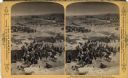
| Date: | 1893 |
|---|---|
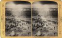
| Description: | A depiction of Jerusalem on the day of Jesus' crucifixion. In the foreground is a crowd of people, animals, and tents. There is also a group of solders wi... |
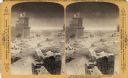
| Date: | 1893 |
|---|---|
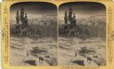
| Description: | A depiction of Akra in Jerusalem on the day of Jesus' crucifixion. A busy landscape of people, animals, and shelters. |
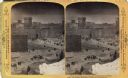
| Date: | 1893 |
|---|---|
| Description: | A depiction of Jerusalem on the day of Jesus' crucifixion. This may be the Eastern end of Mount Zion or the City of David. Text at right: "Wanderings Among... |
| Date: | 1893 |
|---|---|
| Description: | A depiction of Jerusalem on the day of Jesus' crucifixion. In the background, there is Herodian architecture and the Hezekiah's Pool.Text at right: "Wander... |
| Date: | 1893 |
|---|---|
| Description: | A depiction of the Tower of Phasealis on the day of Jesus' crucifixion. |
| Date: | 1893 |
|---|---|
| Description: | A replication of the crucifixion of Jesus Christ. Depicted is the Damascus Road and the garden of Joseph of Arimathea. Joseph of Arimathea was a wealthy ma... |
| Date: | 1893 |
|---|---|
| Description: | A replication of the crucifixion of Jesus Christ. Depicted is the garden of Joseph of Arimathea and the tomb where Jesus is believed to be the buried. A Ro... |
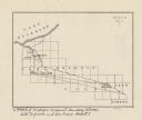
| Date: | |
|---|---|
| Description: | This map shows the Michigan-Wisconsin boundary in Iron, Vilas, and Forest counties, Wisconsin, and Gogebic and Iron counties, Michigan. The Montreal River... |

| Date: | 1929 |
|---|---|
| Description: | High suspension bridge over gorge at Constantine in north eastern Algeria. |

| Date: | 1920 |
|---|---|
| Description: | This blueprint map covers the boundary area between Lake Superior and the Lac Vieux Desert. The map reads: "Land lines, streams, lakes, railroads, cities a... |

| Date: | 1778 |
|---|---|
| Description: | Detailed map of the Chesapeake Bay region and surrounding states. It shows a detailed account of the borders, cities, towns, islands, swamps, mountains, ri... |
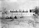
| Date: | 12 1927 |
|---|---|
| Description: | Men are sitting on the ground outside the walls of a town in the Sahara Desert. |
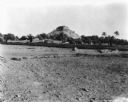
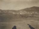
| Date: | 01 30 1929 |
|---|---|
| Description: | View of distant town, perhaps in the Sahara Desert in Tanganyika, Africa. |
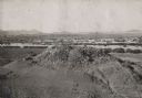
| Date: | 11 15 1925 |
|---|---|
| Description: | View of the tomb of Queen Tin Hinan from the south. Three people are standing on top of the tomb. Mountains and the city of El Oued can be seen in the back... |
| Date: | |
|---|---|
| Description: | Oulon-Kichla an ancient Tartar city on the edge of the Taurus Mountains. |
If you didn't find the material you searched for, our Library Reference Staff can help.
Call our reference desk at 608-264-6535 or email us at: