Filter: Categories of Wisconsin Historical Images
Filter: Subject of Cities and towns
Filter: County of Jefferson
Filter: Year of 1800-1899
Filter: Year of 1890-1899
Filter: Categories of Wisconsin Historical Images
Filter: Subject of Cities and towns
Filter: County of Jefferson
Filter: Year of 1800-1899
Filter: Year of 1890-1899

| Date: | 1893 |
|---|---|
| Description: | This photocopy of a bird’s-eye-view map shows illustrated houses and various buildings. Streets and the Rock River are labeled. An index to points of inter... |

| Date: | 1893 |
|---|---|
| Description: | Bird's-eye map of Jefferson, looking north. Crayfish River at left and center, Rock River from upper center to bottom center, joins at left of center; thir... |
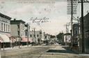
| Date: | 1895 |
|---|---|
| Description: | View of lower Main Street lined with electric power lines and storefronts. Caption reads: "Lower Main Street, Fort Atkinson, Wis." |
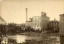
| Date: | 1890 |
|---|---|
| Description: | View across water towards the Empire Mill. Alongside the building are railroad cars at a loading dock. The signs on the mill read: "Globe", "Globe's Empire... |

| Date: | 1895 |
|---|---|
| Description: | Paving Watertown's main street with bricks, with almost as many men who are watching as construction workers. |
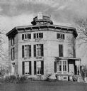
| Date: | 1898 |
|---|---|
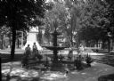
| Description: | Four girls are each standing behind a child sitting in a stroller while posing around Lewis Fountain in Veteran's Park. Houses and the Civil War Veteran's ... |

| Date: | 1896 |
|---|---|
| Description: | A hand-colored Map of Jefferson County, Wisconsin, shows township and section divisions, towns, villages and post offices, rural residents, railroads, road... |
If you didn't find the material you searched for, our Library Reference Staff can help.
Call our reference desk at 608-264-6535 or email us at: