 Filter: Categories of Wisconsin Historical Images
Filter: Subject of Cities and towns
Filter: County of Jefferson
Filter: Subject of railroads
Filter: Categories of Wisconsin Historical Images
Filter: Subject of Cities and towns
Filter: County of Jefferson
Filter: Subject of railroads

| Date: | 1870 |
|---|---|
| Description: | Although the first European settlement in Jefferson was in 1836, the Village of Jefferson was first incorporated as a city in 1878. Made eight years earlie... |

| Date: | 1893 |
|---|---|
| Description: | Bird's-eye map of Jefferson, looking north. Crayfish River at left and center, Rock River from upper center to bottom center, joins at left of center; thir... |
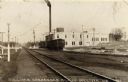
| Date: | 1919 |
|---|---|
| Description: | View across railroad tracks towards the Sullivan Condensed Milk Company. There is a train in front of the factory building. Caption reads: "Sullivan Conden... |

| Date: | 09 1884 |
|---|---|
| Description: | Sanborn map of Fort Atkinson including Barrie, Germany, and North Water Streets. |

| Date: | 09 1884 |
|---|---|
| Description: | Sanborn map of Fort Atkinson including South Water and Milwaukee Streets. |
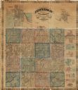
| Date: | 1862 |
|---|---|
| Description: | This map shows townships, landownership, roads, railroads, and swampland in Jefferson County. There is an inset maps showing the towns of: Watertown, Jeffe... |

| Date: | 1896 |
|---|---|
| Description: | A hand-colored Map of Jefferson County, Wisconsin, shows township and section divisions, towns, villages and post offices, rural residents, railroads, road... |

| Date: | |
|---|---|
| Description: | A brochure and map of Jefferson County, Wisconsin, which includes color illustrations, a highway map of the county, a location map, and descriptions of poi... |

| Date: | |
|---|---|
| Description: | A brochure and map of Jefferson County, Wisconsin, that includes illustrations and a location map. Descriptions of points of interest are printed on the op... |

| Date: | |
|---|---|
| Description: | A road map of Jefferson County, Wisconsin, shows different types of roads, townships and sections, towns, railroads, and cities and villages. Cemetery loca... |

| Date: | 1920 |
|---|---|
| Description: | Shows ward boundaries, corporation limits, plat of town, land ownership by name, local streets, parks, railroads, and parts of Rock River. Wards appear in ... |

| Date: | 1976 |
|---|---|
| Description: | Includes index of streets and of local businesses. Shows location of Citizens State Bank, roads, highways, railroads, parks, cemeteries, and city sanitary ... |

| Date: | 1872 |
|---|---|
| Description: | Map shows townships and sections, landownership, roads, railroads, churches, schools, and cemeteries. The map includes business directories of Watertown, J... |

| Date: | 04 1901 |
|---|---|
| Description: | A Sanborn map of Watertown, including an index and a key. |
If you didn't find the material you searched for, our Library Reference Staff can help.
Call our reference desk at 608-264-6535 or email us at:
