 Filter: Categories of Wisconsin Historical Images
Filter: Subject of Cities and towns
Filter: Creator Name of Vinje, Arthur M., 1888-1972
Filter: Categories of Wisconsin Historical Images
Filter: Subject of Cities and towns
Filter: Creator Name of Vinje, Arthur M., 1888-1972

| Date: | 1930 |
|---|---|
| Description: | Aerial view of the University of Wisconsin-Madison campus including Camp Randall Stadium, the Wisconsin State Capitol, and both Lake Mendota and Lake Monon... |
| Date: | 1930 |
|---|---|
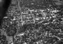
| Description: | Aerial view of the town and the surrounding countryside. |

| Date: | 1930 |
|---|---|
| Description: | Aerial view of the town and the surrounding countryside. |

| Date: | 11 1928 |
|---|---|
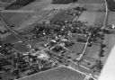
| Description: | Aerial view of Cross Plains, including residences and the surrounding countryside. |
| Date: | 1935 |
|---|---|
| Description: | Aerial view of the French Battery Company facility, East Washington Avenue, and Winnebago Street at the Union Corners intersection. |
| Date: | 1930 |
|---|---|
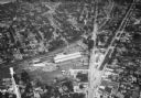
| Description: | Aerial view of the town including the County Courthouse and the surrounding buildings. |

| Date: | 1930 |
|---|---|
| Description: | Aerial view of Tenney Park, including the lagoon, residences surrounding the park, and the shoreline of Lake Mendota on bottom left. |

| Date: | 1930 |
|---|---|
| Description: | Aerial view of Wisconsin Dells including the Wisconsin River and the dam and generating power plant. |

| Date: | 1929 |
|---|---|
| Description: | Aerial view of a construction site surrounded by woods. Lake View Tuberculosis Sanatorium(?). |
| Date: | 1930 |
|---|---|
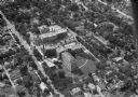
| Description: | Aerial view of Madison General Hospital (currently Meriter Hospital), located on South Park Street, and the surrounding residential neighborhoods. |

| Date: | 1930 |
|---|---|
| Description: | Aerial view of near west side, including West High School, the Forest Products Laboratory, Lake Mendota, and Picnic Point. |

| Date: | 1930 |
|---|---|
| Description: | Aerial view of the Pennco Field (Royal Airport), including the hanger and airplanes on the ground. Lake Monona, the Wisconsin State Capitol, and the Madiso... |
| Date: | 01 13 1955 |
|---|---|
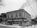
| Description: | Exterior view of the Wilcox Food Shop, 1302 Mound Street, and Vic's Bakery, 1304 Mound Street. Vic's Bakery was owned by Victor Hammersley. Wilcox Food S... |
| Date: | 01 13 1955 |
|---|---|
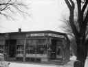
| Description: | Exterior of the Fumusa Superette (Saverio Fumusa) located at 1202 West Dayton Street. |
| Date: | 01 13 1955 |
|---|---|
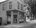
| Description: | Exterior of the Doll Grocery Store located at 2222 South Park Street. Vincent and Sadie Doll operated the store. |
| Date: | 01 13 1955 |
|---|---|
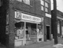
| Description: | Exterior of Bernie's Grocery store located at 334 West Lakeside Street, and a portion of the South Side Bank. The store was operated by Bernard J. Holtman. |
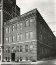
| Date: | 1940 |
|---|---|
| Description: | Exterior view of the Wisconsin Telephone Company Building, 17 South Fairchild Street. |
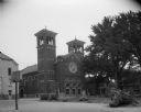
| Date: | 10 05 1955 |
|---|---|
| Description: | Exterior of the St. James Catholic Church, 1130 St. James Court. |
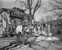
| Date: | 11 08 1952 |
|---|---|
| Description: | Sigma Kappa fraternity house decorated as a showboat for a University of Wisconsin-Madison Homecoming celebration. |

| Date: | 11 07 1952 |
|---|---|
| Description: | The Phi Delta Theta fraternity house, 222 Langdon Street, is decorated for Homecoming with a theme of Bucky Badger whipping the Northwestern University Wil... |
If you didn't find the material you searched for, our Library Reference Staff can help.
Call our reference desk at 608-264-6535 or email us at: