Filter: Categories of Wisconsin Historical Images
Filter: Subject of Church buildings
Filter: Year of 1800-1899
Filter: Year of 1880-1889
Filter: Categories of Wisconsin Historical Images
Filter: Subject of Church buildings
Filter: Year of 1800-1899
Filter: Year of 1880-1889
| Date: | 08 25 1885 |
|---|---|
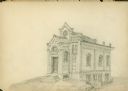
| Description: | Gates of Heaven Synagogue. Designed by August Kutzbock. |

| Date: | 1886 |
|---|---|
| Description: | Bird's-eye view of Bayfield, county seat of Bayfield County. On the lower left side is an inset for Bayfield and the Apostle Islands. |
| Date: | 1885 |
|---|---|
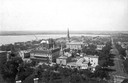
| Description: | View from the Wisconsin State Capitol looking south. Lake Monona is to the left, and West Washington Avenue is on the right. The Dane County Courthouse on ... |
| Date: | 1885 |
|---|---|
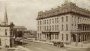
| Description: | Elevated view of the exterior of the Park Hotel at Carroll and Main Streets. There is a church building in the background on the left. |

| Date: | 1884 |
|---|---|
| Description: | Bird's-eye map of Delavan with inset of the State Institute for Deaf and Dumb. |
| Date: | 1883 |
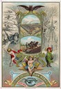
|---|---|
| Description: | Lithographed advertising card for the Oliver Chilled Plow Works commemorating the new year, 1884. The card features two color illustrations within a gold f... |
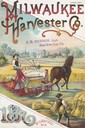
| Date: | 1887 |
|---|---|
| Description: | Cover of an advertising brochure for the Milwaukee Harvester Company featuring a color chromolithograph illustration of farmers in a field with a horse-dra... |

| Date: | 1882 |
|---|---|
| Description: | Bird's-eye views of various sections of Milwaukee. |

| Date: | 1886 |
|---|---|
| Description: | Bird's-eye map of Menomonee Falls. |

| Date: | 1883 |
|---|---|
| Description: | Bird's-eye map of Superior, county seat of Douglas County, on the shores of Lake Superior, with insets of points of interest. |

| Date: | 1880 |
|---|---|
| Description: | Bird's-eye map of Waukesha, county seat of Waukesha County. |

| Date: | 1885 |
|---|---|
| Description: | Bird's-eye map of Waupun on the Rock River. There is an inset at top center of "Althouse, Wheeler & Co., Windmills and Pumps." |

| Date: | 1882 |
|---|---|
| Description: | This map of Cedarburg is a bird's-eye map with an inset of Cedarburg Brewery. Relief is shown pictorially and the map includes an index to buildings. |

| Date: | 1880 |
|---|---|
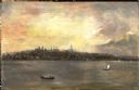
| Description: | Bird's-eye map over the Mississippi River of Fountain City. Paddle steamers and steamboats are on the river, and bluffs are in the background. |

| Date: | 12 21 1882 |
|---|---|
| Description: | Bird's-eye map of Kaukauna, from the Appleton Post Annual Review. |

| Date: | 1883 |
|---|---|
| Description: | Bird's-eye map of Marshfield, with one vignette. |

| Date: | 1881 |
|---|---|
| Description: | Bird's-eye map of Milton Junction. |
If you didn't find the material you searched for, our Library Reference Staff can help.
Call our reference desk at 608-264-6535 or email us at: