 Filter: Categories of Wisconsin Historical Images
Filter: Subject of Church buildings
Filter: Year of 1800-1899
Filter: County of Rock
Filter: Categories of Wisconsin Historical Images
Filter: Subject of Church buildings
Filter: Year of 1800-1899
Filter: County of Rock

| Date: | 1890 |
|---|---|
| Description: | Bird's-eye map of Beloit with insets of Williams Engine Works, Eclipse Wind Engine Co., and John Foster & Co. Turtle Creek is in the lower section, and the... |

| Date: | 1881 |
|---|---|
| Description: | Bird's-eye map of Milton Junction. |
| Date: | 1874 |
|---|---|
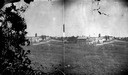
| Description: | View, from a distance, of Fulton Street in Edgerton. A church is in the distance. |
| Date: | 1876 |
|---|---|
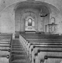
| Description: | Interior of the Rock Prairie Lutheran Church in Luther Valley. Note the model of the sailing ship hanging from the ceiling of the nave, a traditional pract... |
| Date: | 1895 |
|---|---|
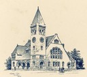
| Description: | Drawing of the Edward Dwight Eaton Chapel at Beloit College. |
| Date: | 1877 |
|---|---|
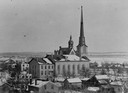
| Description: | Elevated view of the First Congregational Church. Behind the church are buildings in the downtown area. |
| Date: | 1877 |
|---|---|
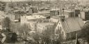
| Description: | Elevated view over houses towards the First Congregational Church in winter. |

| Date: | 1870 |
|---|---|
| Description: | Elevated view over river of Dodge Street in Janesville looking west. |

| Date: | 1870 |
|---|---|
| Description: | Elevated view of the busy streets of Court and Milwaukee. Three prominent buildings in view are: Court Street Methodist Church on the far left (b. 1868), w... |
| Date: | 1893 |
|---|---|
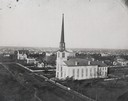
| Description: | Elevated view of the town with All Souls Church in the bottom right corner. |

| Date: | 1858 |
|---|---|
| Description: | This 1858 map of Rock County, Wisconsin, shows the township and range grid, towns, sections, cities and villages, railroads, roads, property owners and res... |

| Date: | 1873 |
|---|---|
| Description: | This map shows landownership and acreages, lot and block numbers, roads and railroads, marshes, schools, churches, mills, rural buildings, and quarries. Re... |

| Date: | 1850 |
|---|---|
| Description: | This map shows a plat of the town, land owners by name, local streets, railroads, churches, and part of the Rock River. The map is also indexed by church d... |
If you didn't find the material you searched for, our Library Reference Staff can help.
Call our reference desk at 608-264-6535 or email us at: