 Filter: Categories of Wisconsin Historical Images
Filter: Subject of Church buildings
Filter: Year of 1800-1899
Filter: County of Fond du Lac
Filter: Categories of Wisconsin Historical Images
Filter: Subject of Church buildings
Filter: Year of 1800-1899
Filter: County of Fond du Lac

| Date: | 1867 |
|---|---|
| Description: | Birds eye drawing of Fond du Lac depicts street names and street layouts, houses, buildings, trees, and the Fond du Lac River. A reference key at the botto... |

| Date: | 1885 |
|---|---|
| Description: | Bird's-eye map of Waupun on the Rock River. There is an inset at top center of "Althouse, Wheeler & Co., Windmills and Pumps." |

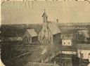
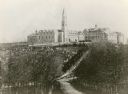
| Date: | 1865 |
|---|---|
| Description: | Elevated view of the Congregational church and surrounding buildings. |
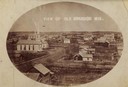
| Date: | 1880 |
|---|---|
| Description: | Elevated view of town, including a church and multiple surrounding buildings. |
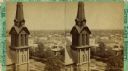
| Date: | 1875 |
|---|---|
| Description: | Elevated stereograph view of the business district, with the spire of the Congregational Church in the foreground. |
| Date: | 1864 |
|---|---|
| Description: | Elevated view of St. Peter's Episcopal Church. |
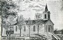
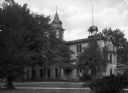
| Date: | 1854 |
|---|---|
| Description: | Exterior view of a First Congregational Church. |
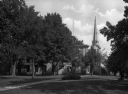
| Date: | 1893 |
|---|---|
| Description: | View down tree-lined road, with Mount Calvary College on a hill in the distance. |
| Date: | 1851 |
|---|---|
| Description: | View across lawn toward the chapel at Ripon College. The roof has a central bell tower and a smaller, secondary tower to the right. |
| Date: | 1851 |
|---|---|
| Description: | View across lawn toward the chapel at Ripon College. The bottom half of the structure is made of brick and has tall, stained-glass windows. Above this is a... |

| Date: | 1851 |
|---|---|
| Description: | View across lawn toward the chapel at Ripon College. The bottom half of the structure is made of brick and has tall, stained-glass windows. Above this is a... |
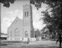
| Date: | 1870 |
|---|---|
| Description: | View across street toward the exterior of Immanuel's Kirche dur Evangelical German church. All the arched windows are decorated with stained glass, mostly ... |

| Date: | 1862 |
|---|---|
| Description: | This map shows townships and sections, landownership and acreages, roads, railroads, cemeteries, churches, schools, mills, and stone quarries. "Engraved, p... |

| Date: | 1874 |
|---|---|
| Description: | Includes index to key buildings. Shows local streets, railroads, fairgrounds, mills, schools, churches, and part of Lake Winnebago. Streets running west to... |

| Date: | 1800 |
|---|---|
| Description: | Shows plat of town, land ownership by name, local streets, courthouses, churches, hotels, mills, railroads, railroad stations, lakes, and rivers. Includes ... |
If you didn't find the material you searched for, our Library Reference Staff can help.
Call our reference desk at 608-264-6535 or email us at: