 Filter: Categories of Wisconsin Historical Images
Filter: Subject of Church buildings
Filter: Subject of trails
Filter: Categories of Wisconsin Historical Images
Filter: Subject of Church buildings
Filter: Subject of trails

| Date: | 1910 |
|---|---|
| Description: | View of an unpaved street in Prairie Farm, lined on the left with multiple buildings, including three churches. Along the right side of the road is a dirt ... |

| Date: | |
|---|---|
| Description: | View down Denniston Avenue. On the left side behind a long row of fences along the sidewalk are dwellings and a church. On the right side dwellings are alo... |

| Date: | 1970 |
|---|---|
| Description: | This pictorial map of Dunn County, Wisconsin, from the 1970s depicts historical events that occurred in the county. It shows cemeteries, churches, schools,... |

| Date: | 1873 |
|---|---|
| Description: | This 1873 map of Chippewa County, Wisconsin, which at the time also encompassed all or part of Price, Rusk, Sawyer, and Taylor counties, shows the township... |

| Date: | 1935 |
|---|---|
| Description: | This map shows railroads, telephone lines, roads, trails, schools, sub-agency, lookout stations, churches, community centers, and school site and farm. Bil... |
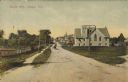
| Date: | 10 28 1907 |
|---|---|
| Description: | Text on front reads: "Maple Ave., Sawyer, Wis." A view of an unpaved street with a church and other buildings on the right. On the left is a path, fence an... |
If you didn't find the material you searched for, our Library Reference Staff can help.
Call our reference desk at 608-264-6535 or email us at: