 Filter: Categories of Wisconsin Historical Images
Filter: Subject of Church buildings
Filter: Subject of streams
Filter: Categories of Wisconsin Historical Images
Filter: Subject of Church buildings
Filter: Subject of streams

| Date: | 1871 |
|---|---|
| Description: | Birds eye map of Brodhead, WI depicts street names and street locations, houses, and trees. A reference key at the bottom of the map shows the locations of... |
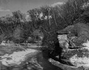
| Date: | 1950 |
|---|---|
| Description: | View looking up at the Methodist Episcopal church over tree covered formations on the banks of Arkansaw Creek. |
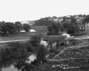
| Date: | |
|---|---|
| Description: | Elevated view of a stream with a dam and a bridge. There is a small fenced garden along the water. In the distance is a hillside with houses. |

| Date: | 1926 |
|---|---|
| Description: | A topographic map of Green County, showing by contours and spot heights the topographic and natural features of the county. The contour intervals are 20 fe... |

| Date: | 1896 |
|---|---|
| Description: | A map of Green Lake County, Wisconsin, shows township divisions, villages and post offices, railroads, roads, lakes and streams, schools, and churches. |

| Date: | |
|---|---|
| Description: | A map that shows the Wisconsin Central Railway land grant lands for sale by the Soo Line, the Chicago, Milwaukee, and St. Paul Railway. Town sections, lak... |

| Date: | 1896 |
|---|---|
| Description: | A hand-colored Map of Jefferson County, Wisconsin, shows township and section divisions, towns, villages and post offices, rural residents, railroads, road... |

| Date: | 1946 |
|---|---|
| Description: | A map showing the roads, railroads, towns, cities and villages, streams and lakes, airports, schools, churches, cemeteries, and golf courses in Kenosha Cou... |

| Date: | 1915 |
|---|---|
| Description: | This 1915 map of Lincoln County, Wisconsin, shows the township and range grid, towns, cities and villages, lakes and streams, residences, churches, school ... |

| Date: | 1926 |
|---|---|
| Description: | A map of Lincoln County, Wisconsin that shows the township and range grid, towns, cities and villages, lakes and streams, residences, churches, school hous... |

| Date: | 1900 |
|---|---|
| Description: | A map of Marinette County, Wisconsin shows the township and range system, sections, towns, cities and villages, streams and lakes, railroads, roads, school... |

| Date: | 1858 |
|---|---|
| Description: | An ink on paper map of Milwaukee County and the eastern portion of Waukesha County that shows the townships of Oak Creek, Franklin, Greenfield, Wauwatosa, ... |

| Date: | 1922 |
|---|---|
| Description: | This map from the early to mid-20th century shows the township and range system, towns, cities and villages, roads, railroads, schools, churches, cemeterie... |

| Date: | 1922 |
|---|---|
| Description: | This map from the early to mid-20th century shows the township and range system, towns, cities and villages, roads, railroads, schools, churches, and lakes... |

| Date: | 1903 |
|---|---|
| Description: | This 1903 map of Outagamie County, Wisconsin, shows the township and range grid, towns, sections, cities and villages, landownership and acreages, rural ma... |

| Date: | |
|---|---|
| Description: | This 1907 map of Outagamie County, Wisconsin, shows the township and range grid, towns, sections, cities and villages, railroads, wagon roads, churches, sc... |

| Date: | 1922 |
|---|---|
| Description: | This map of Outagamie County, Wisconsin, from the first half of the 20th century, shows the township and range grid, towns, sections, cities and villages, ... |

| Date: | 1922 |
|---|---|
| Description: | This map of Pierce County, Wisconsin, from the first half of the 20th century, shows the township and range grid, towns, sections, villages, roads, railroa... |

| Date: | |
|---|---|
| Description: | This map from the early 20th century shows the township and range grid, towns, sections, cities and villages, railroads, roads, schools, churches, and stre... |

| Date: | |
|---|---|
| Description: | This map from the early 20th century shows the township and range grid, towns, sections, cities and villages, railroads, roads, schools, churches, cemeteri... |
If you didn't find the material you searched for, our Library Reference Staff can help.
Call our reference desk at 608-264-6535 or email us at: