 Filter: Categories of Wisconsin Historical Images
Filter: Subject of Church buildings
Filter: Subject of road construction industry
Filter: Categories of Wisconsin Historical Images
Filter: Subject of Church buildings
Filter: Subject of road construction industry

| Date: | 1952 |
|---|---|
| Description: | View towards of men using an M-61 to spread asphalt at Wolters Air Force Base. A building, possibly a church or chapel, stands in the background along the ... |

| Date: | 1915 |
|---|---|
| Description: | Exterior view of the church. The building features a bell steeple, stained glass windows, and double front doors. There is a fenced lot and a barn to the l... |

| Date: | 1896 |
|---|---|
| Description: | This 1896 map shows the township and range system, sections, cities and villages, railroads, roads, vacant land and land sold by the Wisconsin Central Rail... |
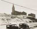
| Date: | 1934 |
|---|---|
| Description: | Terracing on Ellis Street during the winter. Two automobiles are parked alongside the road in the foreground. The terraced hill is snow covered, and a chur... |
If you didn't find the material you searched for, our Library Reference Staff can help.
Call our reference desk at 608-264-6535 or email us at: