Filter: Categories of Wisconsin Historical Images
Filter: Subject of Church buildings
Filter: Subject of railroad tracks
Filter: Categories of Wisconsin Historical Images
Filter: Subject of Church buildings
Filter: Subject of railroad tracks

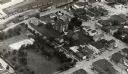
| Date: | 1908 |
|---|---|
| Description: | A panoramic aerial view of the Isthmus taken from a kite. Lake Mendota is to the right in the background with Picnic Point jutting into the lake. The photo... |
| Date: | |
|---|---|
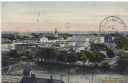
| Description: | Elevated view from south side of the Chippewa River, with a bridge crossing it and buildings on both sides of the river. A bluff rises on the far side of t... |

| Date: | 1881 |
|---|---|
| Description: | Bird's-eye map of Milton Junction. |
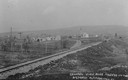
| Date: | 1910 |
|---|---|
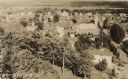
| Description: | Distant view of the town, with railroad tracks in foreground. The church is the highest point in the image. "General View. Blue Mounds in the Distance. Alt... |
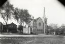
| Date: | 1918 |
|---|---|
| Description: | Exterior view of Saint John's Lutheran Church of 320-322 East Washington Avenue. |

| Date: | 1929 |
|---|---|
| Description: | View from the tower of the Congregational Church towards Lake Mendota and the University of Wisconsin-Madison campus. Picnic Point is in the center backgro... |
| Date: | |
|---|---|
| Description: | Elevated view of town buildings as seen from Bancroft Tower. A body of water and what appears to be an industrial plant are in the foreground. |

| Date: | |
|---|---|
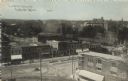
| Description: | View down street of an intersection with railroad tracks and a streetlamp hanging from wires. There are storefronts on both sides of the street, and numero... |

| Date: | |
|---|---|
| Description: | View at an intersection looking down snowy street across railroad tracks. There are storefronts on both sides. A streetlamp hangs from a utility line. At t... |
| Date: | 1903 |
|---|---|
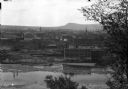
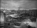
| Description: | View from railroads tracks of the wreckage of wooden buildings left behind after a flood. Intact buildings are visible in a skyline in the distance, and pe... |

| Date: | |
|---|---|
| Description: | View of the village from the railroad tracks. There is a church among the cluster of homes. |
| Date: | |
|---|---|
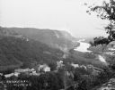
| Description: | Bird's-eye view from bluff. Far below is Main Street and the Mississippi River. The Bay State House facade can be seen among the buildings lining Main Stre... |
| Date: | |
|---|---|
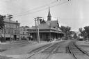
| Description: | View down railroad tracks of the Leominster Railroad Depot. A boy can be seen riding his bicycle on the platform. Beyond the station stands Columbia Hotel,... |
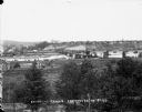
| Date: | 1932 |
|---|---|
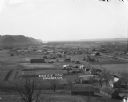
| Description: | Aerial view of town looking down from hill lined with trees. In the foreground railroad tracks cross a road. A church building and numerous dwellings are a... |
| Date: | 1908 |
|---|---|
| Description: | Hand-colored postcard view overlooking a portion of the town. Caption reads: "A Portion of Kendalville, Ind." |
| Date: | |
|---|---|
| Description: | View down hill towards Stoddard, with the Mississippi River and hills in the background. The German Lutheran Church is in the foreground, and there are rai... |

| Date: | |
|---|---|
| Description: | Colorized photographic postcard of an elevated view of central Baraboo from across the railroad tracks. Caption reads: "High Bridge, Baraboo, Wis." |
| Date: | 1910 |
|---|---|
| Description: | Elevated view of a train depot surrounded by a central business district. Horses and wagons are in the street in the foreground. Caption reads: "C. & N.W. ... |
If you didn't find the material you searched for, our Library Reference Staff can help.
Call our reference desk at 608-264-6535 or email us at: