 Filter: Categories of Wisconsin Historical Images
Filter: Subject of Church buildings
Filter: Subject of prisons
Filter: Categories of Wisconsin Historical Images
Filter: Subject of Church buildings
Filter: Subject of prisons

| Date: | 1885 |
|---|---|
| Description: | Bird's-eye map of Waupun on the Rock River. There is an inset at top center of "Althouse, Wheeler & Co., Windmills and Pumps." |
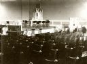
| Date: | 1910 |
|---|---|
| Description: | View of the chapel in the Wisconsin State Prison. In the foreground are chairs, and in front of the stage is a piano. |

| Date: | 1899 |
|---|---|
| Description: | This 1899 map of Dodge County, Wisconsin, shows the township and range grid, towns, sections, cities and villages, roads, railroads, post offices, cemeteri... |

| Date: | 1789 |
|---|---|
| Description: | Map of New York City showing ward boundaries, ferries, streets, roads, swamps, ponds, and rivers. The properties of Lispinard, Byards, Jones, Rutgers, and ... |
If you didn't find the material you searched for, our Library Reference Staff can help.
Call our reference desk at 608-264-6535 or email us at: