 Filter: Categories of Wisconsin Historical Images
Filter: Subject of Church buildings
Filter: Subject of postal service
Filter: Categories of Wisconsin Historical Images
Filter: Subject of Church buildings
Filter: Subject of postal service
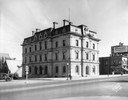
| Date: | 08 01 1929 |
|---|---|
| Description: | The old U.S. Post Office and Federal Building at 4 East Mifflin Street, just months before it was torn down and replaced by Manchester's Department store. ... |

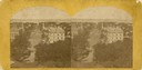
| Date: | 1870 |
|---|---|
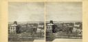
| Description: | Stereograph looking south from the post office at the corner of Mifflin Street and Wisconsin Avenue across one corner of the Capitol Square toward Grace Ep... |
| Date: | 1876 |
|---|---|
| Description: | Elevated view from the Wisconsin State Capitol looking north to Lake Mendota along Wisconsin Avenue. City Hall is on the left, built in 1858, and the Feder... |

| Date: | 1915 |
|---|---|
| Description: | Wisconsin Avenue looking toward the northwest from the top of the Capitol. The elevated perspective provides an unusual view of the old City Hall (left) an... |
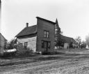
| Date: | 1909 |
|---|---|
| Description: | Exterior view of the log building which served as the post office in Loreta (formerly known as Loreto) until January 31, 1907. There is a church in the bac... |

| Date: | 1868 |
|---|---|
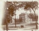
| Description: | Elevated view up Wisconsin Avenue showing City Hall on the corner at Mifflin Street on the left, with the Post Office to the right. Further down is the Pre... |
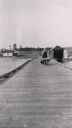
| Date: | 1910 |
|---|---|
| Description: | Mrs. Lathrop, the town post mistress, pushing her wheelbarrow down a long wooden dock at La Pointe. She is on her way to haul merchandise for her store. |

| Date: | 1902 |
|---|---|
| Description: | View across Mifflin Street towards the old Madison Post Office, with a streetcar stopped in front of the building. |
| Date: | 1908 |
|---|---|
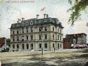
| Description: | Colorized view of the U.S. Post Office and its surrounding streets. Caption reads: "Post Office, Madison, Wis." |

| Date: | 1890 |
|---|---|
| Description: | A view looking down Wisconsin Avenue as seen from the Wisconsin State Capitol grounds. On the right, the post office is visible. |

| Date: | 1918 |
|---|---|
| Description: | Unitarian Church, built in 1886, and parish hall added in 1911 (both demolished), 125 Wisconsin Avenue at East Dayton Street, with a corner of the Federal ... |
| Date: | |
|---|---|
| Description: | Elevated view up Wisconsin Avenue showing City Hall with the Post Office to the right. Also visible is the Presbyterian Church. |

| Date: | |
|---|---|
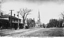
| Description: | View down dirt road toward a small horse-drawn carriage and surrounding town buildings, including the post office and a church with a steeple. Caption read... |

| Date: | 1870 |
|---|---|
| Description: | Stereograph looking south from the post office at the corner of Mifflin Street and Wisconsin Avenue across one corner of the Capitol Square toward Grace Ep... |
| Date: | 1915 |
|---|---|
| Description: | A wooden chest with a sign "[illegible] Cement Work" stands on West Dayton Street near its intersection with Wisconsin Avenue. There is a bucket nearby, an... |
| Date: | |
|---|---|
| Description: | View of the town center with shops, a church, and a horse and wagons. |

| Date: | |
|---|---|
| Description: | View of Central Town Square featuring a post office, stores, a park, and a church. Published by R.W. Emerson. |

| Date: | 1896 |
|---|---|
| Description: | A map of Green Lake County, Wisconsin, shows township divisions, villages and post offices, railroads, roads, lakes and streams, schools, and churches. |

| Date: | 1858 |
|---|---|
| Description: | An ink on paper map of Milwaukee County and the eastern portion of Waukesha County that shows the townships of Oak Creek, Franklin, Greenfield, Wauwatosa, ... |

| Date: | 1886 |
|---|---|
| Description: | A hand-colored map of Milwaukee County, Wisconsin that shows the township and range system, sections, towns, roads, railroads and rail stations, cities and... |
If you didn't find the material you searched for, our Library Reference Staff can help.
Call our reference desk at 608-264-6535 or email us at: