 Filter: Categories of Wisconsin Historical Images
Filter: Subject of Church buildings
Filter: Subject of grist mills
Filter: Categories of Wisconsin Historical Images
Filter: Subject of Church buildings
Filter: Subject of grist mills

| Date: | 1914 |
|---|---|
| Description: | Map shows school houses, creameries, post offices, saw mills, grist mills, churches, cemeteries, town halls, stores, roads, state roads, and railroads. "Co... |

| Date: | 12 1912 |
|---|---|
| Description: | Sanborn Map of Sun Prairie. The map highlights the public and parochial schools, the exhange, and church buildings, etc. |
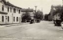
| Date: | |
|---|---|
| Description: | View looking up Columbia Avenue, with the Merchants Bank on the left, and a mill, and a church further down on the right. Automobiles are parked along the ... |
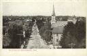
| Date: | 1908 |
|---|---|
| Description: | Elevated view looking down Main Street. A church is on the right, surrounded by dwellings obscured by trees. A mill is in the distance. Caption reads: "Mai... |
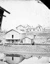
| Date: | 1879 |
|---|---|
| Description: | Slightly elevated view across a river toward a large building with Greenwood Mills written on the side. The mill is reflected in the river in the foregroun... |
If you didn't find the material you searched for, our Library Reference Staff can help.
Call our reference desk at 608-264-6535 or email us at:
