 Filter: Categories of Wisconsin Historical Images
Filter: Subject of Church buildings
Filter: Subject of farmhouses
Filter: Categories of Wisconsin Historical Images
Filter: Subject of Church buildings
Filter: Subject of farmhouses
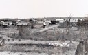
| Date: | 1900 |
|---|---|
| Description: | View from hill across field towards farmhouses, dwellings and churches along a road. In the foreground are stumps. Caption reads: "Big Falls, Wis." |
| Date: | 1928 |
|---|---|
| Description: | View from hill of uptown Cross Plains with the Catholic Church (St. Francis Xavier) and farmhouses. |

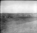
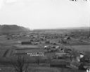
| Date: | 1900 |
|---|---|
| Description: | Distant view from hill looking down toward small village's main street and surrounding countryside. |
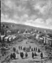
| Date: | 1909 |
|---|---|
| Description: | Painting of an elevated view of Pilgrims and Native Americans meeting in a town. |
| Date: | |
|---|---|
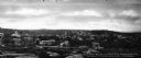
| Description: | Panoramic view of the town's East end and surrounding woods. Caption reads, "Bird's-eye view of East End, Whitinsville, Mass." |
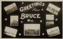
| Date: | 05 15 1909 |
|---|---|
| Description: | Photographic postcard of a poster promoting Bruce with seven photographs. The fairgrounds, Main Street, farm scene, Catholic Church, Chippewa River bridge,... |

| Date: | |
|---|---|
| Description: | View from a hilltop looking down at the village. On the hilltop, there is a small tree. In the village are homes, a church, shops, and in the far distance,... |
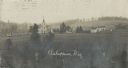
| Date: | 1909 |
|---|---|
| Description: | Elevated view of a church with cemetery and farmhouses and rolling hills in the distance. Caption reads: "Ashippun, Wis." |
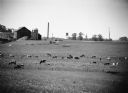
| Date: | 1955 |
|---|---|
| Description: | "Cows graze on the William Engman farm south of Theresa. The new water tower, at right, is being constructed." |

| Date: | 01 1983 |
|---|---|
| Description: | "This photo of Theresa was taken from the Ralph Bodden farm. The long 500mm mirror lens compresses the distance from the Paul Koll farm in the foreground t... |

| Date: | 01 1983 |
|---|---|
| Description: | "This photo of Theresa was taken from the Ralph Bodden farm. The long 500mm mirror lens compresses the distance from the Paul Koll farm in the foreground t... |

| Date: | 1897 |
|---|---|
| Description: | This 1897 map of Sawyer County, Wisconsin, shows the township and range system, sections, roads, farm houses, camps, school houses, dams, bridges, Indian r... |

| Date: | 1877 |
|---|---|
| Description: | Shows land ownership by name, churches, schools, farm houses, wagon roads, railroads. Includes directory of businesses for Columbus, Portage, Doylestown, W... |

| Date: | 1900 |
|---|---|
| Description: | Shows lands belonging to Wisconsin Timber and Land Co., towns, post offices, saw mills, creameries, camps, churches, schools, farm houses, town halls, rail... |
| Date: | |
|---|---|
| Description: | View down hill towards Stoddard, with the Mississippi River and hills in the background. The German Lutheran Church is in the foreground, and there are rai... |

| Date: | 1928 |
|---|---|
| Description: | View from grassy hill of uptown Cross Plains. The Catholic Church (St. Francis Xavier) is on the right, and farmhouses and other buildings are among fields... |

| Date: | 1900 |
|---|---|
| Description: | View across lawn towards a man, on the far left, riding a horse-drawn mower towards an open gate. A picket fence runs along the right side, with a farmhous... |

| Date: | 1900 |
|---|---|
| Description: | This map shows landownership, churches, schools, farm houses, wagon roads, railroads, and townships and includes businesses advertisements, tables of stati... |
If you didn't find the material you searched for, our Library Reference Staff can help.
Call our reference desk at 608-264-6535 or email us at: