 Filter: Categories of Wisconsin Historical Images
Filter: Subject of Church buildings
Filter: Subject of business
Filter: Categories of Wisconsin Historical Images
Filter: Subject of Church buildings
Filter: Subject of business

| Date: | 1890 |
|---|---|
| Description: | Bird's-eye map of Beloit with insets of Williams Engine Works, Eclipse Wind Engine Co., and John Foster & Co. Turtle Creek is in the lower section, and the... |

| Date: | 1891 |
|---|---|
| Description: | Bird's-eye map of Stevens Point, looking east, with an inset of the Water Works. Wisconsin River in foreground with fifty-three business locations identifi... |

| Date: | 1874 |
|---|---|
| Description: | Distant view of the town from a hill with houses, garden plots, businesses and churches. |
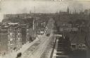
| Date: | 1910 |
|---|---|
| Description: | Elevated view looking east along West State Street between Eighth and Ninth Streets. Numerous buildings line the road, along which cable cars are travelin... |

| Date: | 1876 |
|---|---|
| Description: | This 1876 map of Saint Croix County, Wisconsin, shows the township and range grid, sections, towns, cities and villages, land ownership and acreages, wagon... |

| Date: | 1877 |
|---|---|
| Description: | This 1877 map of Trempealeau County, Wisconsin, shows the township and range grid, sections, towns, cities and villages, land ownership and acreages, roads... |

| Date: | 1878 |
|---|---|
| Description: | This 1878 map of Vernon County, Wisconsin, shows the township and range grid, sections, towns, cities and villages, land ownership and acreages, roads, rai... |

| Date: | 1860 |
|---|---|
| Description: | This map of Dodge County, Wisconsin, shows the township and range grid, towns, sections, cities and villages, railroads, roads, property owners and acreage... |

| Date: | 1896 |
|---|---|
| Description: | This late 19th-century map of Dodge County, Wisconsin, shows the township and range grid, towns, sections, cities, villages and post offices, some property... |

| Date: | 1873 |
|---|---|
| Description: | This 1873 map of Winnebago County, Wisconsin, shows the township and range grid, towns, sections, cities and villages, landownership and acreages, roads, r... |

| Date: | 1877 |
|---|---|
| Description: | Shows land ownership by name, churches, schools, farm houses, wagon roads, railroads. Includes directory of businesses for Columbus, Portage, Doylestown, W... |

| Date: | 1862 |
|---|---|
| Description: | Shows townships and sections, landownership and acreage, roads, railroads, churches, schools, and cemeteries. Inset maps: Plat of Hingham -- Plat of Casca... |

| Date: | 1966 |
|---|---|
| Description: | This 1966 map shows topography, roads, highways, golf courses, government buildings, and businesses around Delavan Lake in Walworth County, Wisconsin. Incl... |

| Date: | 1858 |
|---|---|
| Description: | This 1858 map of Rock County, Wisconsin, shows the township and range grid, towns, sections, cities and villages, railroads, roads, property owners and res... |

| Date: | 1863 |
|---|---|
| Description: | Includes index to public buildings, churches, schools. Inset: Glidden & Lockwood’s addition. Gives names of some property owners. |

| Date: | 05 1958 |
|---|---|
| Description: | Photocopy of a map created by the City of Milwaukee Master Plan Program City Planning Division in May of 1958 representing 1870 "THE CENTRAL AREA OF THE CI... |

| Date: | 1940 |
|---|---|
| Description: | Map features advertisements for local businesses on the left and bottom. Map includes a "LEGEND" and "DIRECTORY OF CHURCHES". Streets are labeled as are so... |

| Date: | 1916 |
|---|---|
| Description: | Includes index to businesses, churches, and schools. Shows local streets, buildings, railroads, ward divisions, Fond du Lac River, and part of Lake Winneba... |

| Date: | 1872 |
|---|---|
| Description: | Shows townships and sections, landownership and acreages, roads, railroads, churches, schools, and cemeteries. Includes business directories of Manitowoc ... |

| Date: | 1873 |
|---|---|
| Description: | Map shows townships and sections, landownership and acreages, state and county lands, churches, schools, cemeteries, roads, and railroads. There is an inse... |
If you didn't find the material you searched for, our Library Reference Staff can help.
Call our reference desk at 608-264-6535 or email us at: