 Filter: Categories of Wisconsin Historical Images
Filter: Subject of Church buildings
Filter: Subject of botany
Filter: Categories of Wisconsin Historical Images
Filter: Subject of Church buildings
Filter: Subject of botany

| Date: | 1882 |
|---|---|
| Description: | This map of Cedarburg is a bird's-eye map with an inset of Cedarburg Brewery. Relief is shown pictorially and the map includes an index to buildings. |

| Date: | 1878 |
|---|---|
| Description: | Bird's-eye map of Chilton with insets of points of interest, including P.H. Becker's Brewery, Chilton House, and Gutheil's Block. |

| Date: | 1874 |
|---|---|
| Description: | Bird's-eye map of Chippewa Falls. |

| Date: | 1896 |
|---|---|
| Description: | Bird's-eye map of Darlington. Area bordered by Washington and North Streets, upper left hand corner, the fairgrounds, upper right corner, River Street, bot... |

| Date: | 1872 |
|---|---|
| Description: | Birds-eye drawing of Eau Claire depicts street names and street locations, houses, trees, bridges, piers, canals, railroads, and the Chippewa and Eau Clair... |

| Date: | 1891 |
|---|---|
| Description: | Bird's-eye view of Eau Claire. |

| Date: | 1880 |
|---|---|
| Description: | Bird's-eye map over the Mississippi River of Fountain City. Paddle steamers and steamboats are on the river, and bluffs are in the background. |

| Date: | 1893 |
|---|---|
| Description: | Bird's-eye map of Jefferson, looking north. Crayfish River at left and center, Rock River from upper center to bottom center, joins at left of center; thir... |

| Date: | 12 21 1882 |
|---|---|
| Description: | Bird's-eye map of Kaukauna, from the Appleton Post Annual Review. |

| Date: | 1879 |
|---|---|
| Description: | Bird's-eye map of Lake Mills. |

| Date: | 1883 |
|---|---|
| Description: | Bird's-eye map of Marshfield, with one vignette. |

| Date: | 1881 |
|---|---|
| Description: | Bird's-eye map of Milton Junction. |
| Date: | 03 13 1946 |
|---|---|
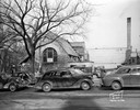
| Description: | First Unitarian Society Meeting House, 125 Wisconsin Avenue, being razed by Arneson Wrecking Company. View is from Wisconsin Avenue. On the left is the edu... |
| Date: | 06 20 1944 |
|---|---|
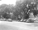
| Description: | Cars parked in the 200 block of West Washington Avenue. Properties shown are, right to left, Fiore Filling Station parking lot, U.S. Government warehouse (... |
| Date: | 06 22 1941 |
|---|---|
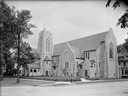
| Description: | Exterior view of the Bethel Lutheran Church, 318 Wisconsin Avenue. |
| Date: | 05 13 1941 |
|---|---|
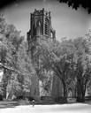
| Description: | St. Bernard's Catholic Church, 2460 Atwood Avenue. |
| Date: | 02 18 1939 |
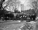
|---|---|
| Description: | Group portrait of Central High School driving license class holding certificates and standing beside "AAA Dual Control Driver Training Car." They are stand... |
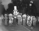
| Date: | 07 24 1935 |
|---|---|
| Description: | Children, from Hawthorne School Annex, wearing Mardi Gras style heads, are marching in the Lantern Parade, with the First Evangelical Church in the backgro... |
If you didn't find the material you searched for, our Library Reference Staff can help.
Call our reference desk at 608-264-6535 or email us at:

