 Filter: Categories of Wisconsin Historical Images
Filter: Subject of Church buildings
Filter: County of Jefferson
Filter: Year of 1800-1899
Filter: Categories of Wisconsin Historical Images
Filter: Subject of Church buildings
Filter: County of Jefferson
Filter: Year of 1800-1899

| Date: | 1870 |
|---|---|
| Description: | Although the first European settlement in Jefferson was in 1836, the Village of Jefferson was first incorporated as a city in 1878. Made eight years earlie... |

| Date: | 1893 |
|---|---|
| Description: | Bird's-eye map of Jefferson, looking north. Crayfish River at left and center, Rock River from upper center to bottom center, joins at left of center; thir... |

| Date: | 1879 |
|---|---|
| Description: | Bird's-eye map of Lake Mills. |
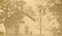
| Date: | 1885 |
|---|---|
| Description: | View of the Methodist Church and parsonage, with Reverend Elvardo Cyrus Potter standing outside with his daughter, Grace. |
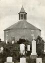
| Date: | 1885 |
|---|---|
| Description: | Norwegian Octagon church, built in 1852 and torn down about 1891 or 1892. |

| Date: | 09 1884 |
|---|---|
| Description: | Sanborn map of Fort Atkinson including South Water and Milwaukee Streets. |

| Date: | 1896 |
|---|---|
| Description: | A hand-colored Map of Jefferson County, Wisconsin, shows township and section divisions, towns, villages and post offices, rural residents, railroads, road... |

| Date: | 1872 |
|---|---|
| Description: | Map shows townships and sections, landownership, roads, railroads, churches, schools, and cemeteries. The map includes business directories of Watertown, J... |

| Date: | 1857 |
|---|---|
| Description: | This map shows lot and block numbers, buildings, some land ownership, wards, waterways, streets, railroads, brick yards, and cemeteries. It includes an ind... |
If you didn't find the material you searched for, our Library Reference Staff can help.
Call our reference desk at 608-264-6535 or email us at:

