 Filter: Categories of Wisconsin Historical Images
Filter: Subject of Church buildings
Filter: County of Jefferson
Filter: Categories of Wisconsin Historical Images
Filter: Subject of Church buildings
Filter: County of Jefferson
| Date: | |
|---|---|
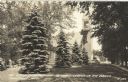
| Description: | Photographic postcard of the oldest Scandinavian Methodist Church in the world. Four large pine trees are growing in the foreground and a tree-shaded side ... |

| Date: | |
|---|---|
| Description: | Photographic postcard of St. James Evangelical Lutheran Church. Trees are on the left and right. Caption reads: "St. James Evangelical Lutheran Church, Cam... |
| Date: | |
|---|---|
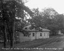
| Description: | A hexagon-shaped chapel along the dirt road. |

| Date: | 06 30 1956 |
|---|---|
| Description: | A bride and groom comes down the aisle after their wedding at St. Peter's Episcopal Church in Fort Atkinson, Wisconsin. The bride is Deborah Wells Jones; h... |

| Date: | |
|---|---|
| Description: | Photographic postcard of the oldest Scandinavian Methodist Church in the world. Two large trees frame the front entrance, with shrubs and trees are around ... |

| Date: | 09 1884 |
|---|---|
| Description: | Sanborn map of Fort Atkinson including South Water and Milwaukee Streets. |

| Date: | 1896 |
|---|---|
| Description: | A hand-colored Map of Jefferson County, Wisconsin, shows township and section divisions, towns, villages and post offices, rural residents, railroads, road... |

| Date: | 1912 |
|---|---|
| Description: | View down street from the end of a bridge. On the left is a service garage, post office and millinery. On the right is a shoe and repair shops, and other c... |
| Date: | 1912 |
|---|---|
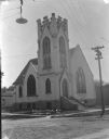
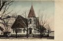
| Description: | View from street of the English Lutheran Church on a corner, showing front and left side of the building. The entrance is under a square bell tower, which ... |

| Date: | 1912 |
|---|---|
| Description: | Elevated view of the river with trees on the left. On the right, two young boys are fishing from a rowboat in the river near a landing at the back of a thr... |

| Date: | 1911 |
|---|---|
| Description: | Map shows in blue roads, railroads, post offices, schools, houses, churches, and routes. The map includes a chart of "Explanation" that acts as a legend. T... |

| Date: | 1872 |
|---|---|
| Description: | Map shows townships and sections, landownership, roads, railroads, churches, schools, and cemeteries. The map includes business directories of Watertown, J... |
| Date: | 1910 |
|---|---|
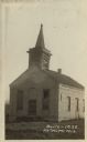
| Description: | Photographic postcard of a three-quarter view of the exterior of an abandoned church. There are broken shutters in the belfry and a broken window in front.... |

| Date: | 1940 |
|---|---|
| Description: | This map of Aztalan is pencil and ink on paper. The map shows streets, local businesses, churches, houses, and the Crawfish River. The map reads: "Informat... |

| Date: | 05 30 1956 |
|---|---|
| Description: | Portrait of the bride at the wedding of Deborah Wells Jones and Malcolm Donaldson, which took place at St. Peter's Episcopal Church in Ft. Atkinson. Debora... |

| Date: | 1857 |
|---|---|
| Description: | This map shows lot and block numbers, buildings, some land ownership, wards, waterways, streets, railroads, brick yards, and cemeteries. It includes an ind... |

| Date: | |
|---|---|
| Description: | Elevated view of Fort Atkinson, with a church in the foreground surrounded by rooftops. Caption reads: "Fort Atkinson, Wis." |
| Date: | 1909 |
|---|---|
| Description: | Hand-colored view of the M.E. Church. Caption reads: "M.E. Church, Fort Atkinson, Wis." |

| Date: | |
|---|---|
| Description: | Hand-colored view of the Episcopal Church and an automobile parked at the curb. Caption reads: "Episcopal Church, Fort Atkinson, Wis." |
If you didn't find the material you searched for, our Library Reference Staff can help.
Call our reference desk at 608-264-6535 or email us at:
